Hammam Sousse geodata
Hammam Sousse (Sūsah) is a populated place; located in Tunisia in Africa/Tunis (GMT+1) time zone. With population of 33,834 people, there are 40 cities with bigger population in this country. Compared to other cities in Tunisia, 51% of cities are located further ↓South; 68.5% of cities are located further ←West and 85.3% of cities have higher elevation than Hammam Sousse. Note1


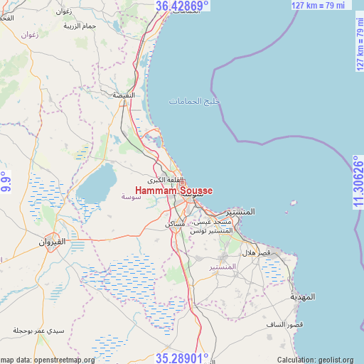
Hammam Sousse GPS coordinates[2]
35° 51' 39.24" North, 10° 36' 11.268" East
| Map corner | latitude | longitude |
|---|---|---|
| Upper-left | 36.42869°, | 9.9° |
| Center: | 35.8609°, | 10.60313° |
| Lower-right: | 35.28901°, | 11.30626° |
| Map W x H: | 126.7×126.7 km | = 78.7×78.7mi |
| max Lat: | 37.27442° ⇑49% North |
| Hammam Sousse: | 35.8609° |
| min Lat: | ⇓51% South 32.31662° |
| min Long | Hammam Sousse | max Long |
| 7.87765° | 10.60313° | 11.21965° |
| W 68.5%⇐ | ⇒31.5% E |
Elevation
Elevation of Hammam Sousse is 10 m = 33 ft, and this is 139.4 m = 457 ft below average elevation for this country.
| Max E: |
999 m = 3278 ft | 85.3% |
| Avg. | 149.4 m = 490 ft | |
| Hammam Sousse | 10 m = 33 ft | |
Min E: |
-6 m = -20 ft | 14.7% |
See also: Tunisia elevation on elevation.city.
Geographical zone
Hammam Sousse is located in North temperate zone (between Tropic of Cancer and the Arctic Circle). Distance of this Northern Tropic circle is 1381.4 km =858.4 mi to South.| Distance of | km | miles | from Hammam Sousse |
|---|---|---|---|
| North Pole | 6019.7 | 3740.5 | to North |
| Arctic Circle | 3413.8 | 2121.2 | to North |
| Tropic Cancer | 1381.4 | 858.4 | to South |
| Equator | 3987.4 | 2477.7 | to South |


Nearby cities:
15 places around Hammam Sousse: (largest is in red/bold)
• Akouda
3.5 km =2.2 mi,  284°
284°
• Banbalah
25.2 km =15.7 mi,  135°
135°
• Djemmal
29.9 km =18.6 mi,  152°
152°
• Harqalah
20.6 km =12.8 mi,  335°
335°
• Ksibet el Mediouni
29.1 km =18.1 mi,  132°
132°
• Menzel Kamel
26.9 km =16.7 mi,  167°
167°
• Mesdour
22.8 km =14.2 mi, 150°
• Monastir
22.1 km =13.7 mi,  114°
114°
• Msaken
14.8 km =9.2 mi,  187°
187°
• Ouardenine
18 km =11.2 mi,  159°
159°
• Port el Kantaoui
3.6 km =2.2 mi,  347°
347°
• Sahline
15.6 km =9.7 mi, 141°
• Sidi Bou Ali
15.8 km =9.8 mi,  312°
312°
• Skanes
19.7 km =12.2 mi,  115°
115°
• Sousse
5 km =3.1 mi, 142°
Sources, notices
• [Note1] Compared only with cities in Tunisia existing in our database
• [Src1] Map data: © OpenStreetMap contributors (CC-BY-SA)
• [Src2] Other city data from geonames.org with taken over terms of usage.
• [Src3] Geographical zone / Annual Mean Temperature by Robert A. Rohde @ Wikipedia
