Harqalah geodata
Harqalah (Sūsah) is a populated place; located in Tunisia in Africa/Tunis (GMT+1) time zone. With population of 6,942 people, there are 103 cities with bigger population in this country. Compared to other cities in Tunisia, 55.9% of cities are located further ↓South; 62.2% of cities are located further ←West and 69.2% of cities have higher elevation than Harqalah. Note1


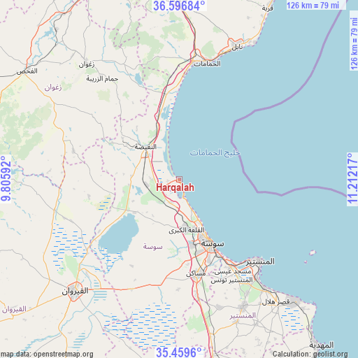
Harqalah GPS coordinates[2]
36° 1' 48.972" North, 10° 30' 32.544" East
| Map corner | latitude | longitude |
|---|---|---|
| Upper-left | 36.59684°, | 9.80592° |
| Center: | 36.03027°, | 10.50904° |
| Lower-right: | 35.4596°, | 11.21217° |
| Map W x H: | 126.4×126.4 km | = 78.5×78.5mi |
| max Lat: | 37.27442° ⇑44.1% North |
| Harqalah: | 36.03027° |
| min Lat: | ⇓55.9% South 32.31662° |
| min Long | Harqalah | max Long |
| 7.87765° | 10.50904° | 11.21965° |
| W 62.2%⇐ | ⇒37.8% E |
Elevation
Elevation of Harqalah is 21 m = 69 ft, and this is 128.4 m = 421 ft below average elevation for this country.
| Max E: |
999 m = 3278 ft | 69.2% |
| Avg. | 149.4 m = 490 ft | |
| Harqalah | 21 m = 69 ft | |
Min E: |
-6 m = -20 ft | 30.8% |
See also: Tunisia elevation on elevation.city.
Geographical zone
Harqalah is located in North temperate zone (between Tropic of Cancer and the Arctic Circle). Distance of this Northern Tropic circle is 1400.3 km =870.1 mi to South.| Distance of | km | miles | from Harqalah |
|---|---|---|---|
| North Pole | 6000.9 | 3728.8 | to North |
| Arctic Circle | 3395 | 2109.6 | to North |
| Tropic Cancer | 1400.3 | 870.1 | to South |
| Equator | 4006.2 | 2489.3 | to South |


Nearby cities:
15 places around Harqalah: (largest is in red/bold)
• Akouda
18.6 km =11.6 mi,  164°
164°
• Banbalah
45.1 km =28 mi,  144°
144°
• Hammam Sousse
20.6 km =12.8 mi, 155°
• Hammamet
42.2 km =26.2 mi,  13°
13°
• Mesdour
43.4 km =27 mi,  153°
153°
• Monastir
40 km =24.9 mi,  134°
134°
• Msaken
34.1 km =21.2 mi,  169°
169°
• Ouardenine
38.7 km =24 mi, 157°
• Port el Kantaoui
17.1 km =10.6 mi, 153°
• Sahline
35.9 km =22.3 mi, 149°
• Sbikha
45.2 km =28.1 mi,  256°
256°
• Sidi Bou Ali
8.8 km =5.5 mi,  201°
201°
• Sidi el Hani
43.5 km =27 mi, 203°
• Skanes
38 km =23.6 mi, 136°
• Sousse
25.5 km =15.8 mi, 153°
Sources, notices
• [Note1] Compared only with cities in Tunisia existing in our database
• [Src1] Map data: © OpenStreetMap contributors (CC-BY-SA)
• [Src2] Other city data from geonames.org with taken over terms of usage.
• [Src3] Geographical zone / Annual Mean Temperature by Robert A. Rohde @ Wikipedia
