Adalan geodata
Adalan (Istanbul) is a populated place; located in Turkey in Europe/Istanbul (GMT+3) time zone. With population of 4,000 people, there are 779 cities with bigger population in this country. Compared to other cities in Turkey, 85.6% of cities are located further ↓South; 83.2% of cities are located further →East and 81.8% of cities have higher elevation than Adalan. Note1


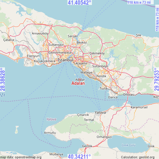
Adalan GPS coordinates[2]
40° 52' 33.24" North, 29° 5' 21.84" East
| Map corner | latitude | longitude |
|---|---|---|
| Upper-left | 41.40542°, | 28.38628° |
| Center: | 40.8759°, | 29.0894° |
| Lower-right: | 40.34211°, | 29.79253° |
| Map W x H: | 118.2×118.2 km | = 73.4×73.4mi |
| max Lat: | 42.02683° ⇑14.4% North |
| Adalan: | 40.8759° |
| min Lat: | ⇓85.6% South 35.9025° |
| min Long | Adalan | max Long |
| 25.90902° | 29.0894° | 44.60099° |
| W 16.8%⇐ | ⇒83.2% E |
Elevation
Elevation of Adalan is 98 m = 322 ft, and this is 619.4 m = 2032 ft below average elevation for this country.
| Max E: |
2682 m = 8799 ft | 81.8% |
| Avg. | 717.4 m = 2354 ft | |
| Adalan | 98 m = 322 ft | |
Min E: |
0 m = 0 ft | 18.2% |
See also: Turkey elevation on elevation.city.
Geographical zone
Adalan is located in North temperate zone (between Tropic of Cancer and the Arctic Circle). Distance of this Northern Tropic circle is 1939.1 km =1204.9 mi to South.| Distance of | km | miles | from Adalan |
|---|---|---|---|
| North Pole | 5462.1 | 3394 | to North |
| Arctic Circle | 2856.2 | 1774.8 | to North |
| Tropic Cancer | 1939.1 | 1204.9 | to South |
| Equator | 4545 | 2824.1 | to South |


Nearby cities:
15 places around Adalan: (largest is in red/bold)
• Adalar
3.8 km =2.4 mi,  103°
103°
• Ataşehir
12.2 km =7.6 mi,  10°
10°
• Eminönü
18.5 km =11.5 mi,  328°
328°
• Istanbul
19.3 km =12 mi,  322°
322°
• Kınalı
4.5 km =2.8 mi, 320°
• Maltepe
8.6 km =5.3 mi,  39°
39°
• Pendik
15.4 km =9.6 mi,  89°
89°
• Samandıra
17.8 km =11.1 mi, 39°
• Sancaktepe
18.5 km =11.5 mi, 40°
• Sultanbeyli
17.9 km =11.1 mi,  58°
58°
• Umraniye
15.9 km =9.9 mi, 10°
• Çekmeköy
19.8 km =12.3 mi,  22°
22°
• Ümraniye
17.5 km =10.9 mi,  3°
3°
• Üsküdar
17.5 km =10.9 mi,  338°
338°
• İçmeler
18.7 km =11.6 mi, 100°
Sources, notices
• [Note1] Compared only with cities in Turkey existing in our database
• [Src1] Map data: © OpenStreetMap contributors (CC-BY-SA)
• [Src2] Other city data from geonames.org with taken over terms of usage.
• [Src3] Geographical zone / Annual Mean Temperature by Robert A. Rohde @ Wikipedia
