Yenipazar geodata
Yenipazar (Yozgat) is a seat of a third-order administrative division; located in Turkey in Europe/Istanbul (GMT+3) time zone. In our database, there are 1323 cities with bigger population. Compared to other cities in Turkey, 60.8% of cities are located further ↓South; 53.9% of cities are located further →East and 72.5% of cities have lower elevation than Yenipazar. Note1


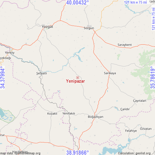
Yenipazar GPS coordinates[2]
39° 27' 48.996" North, 35° 4' 59.016" East
| Map corner | latitude | longitude |
|---|---|---|
| Upper-left | 40.00432°, | 34.37994° |
| Center: | 39.46361°, | 35.08306° |
| Lower-right: | 38.91866°, | 35.78619° |
| Map W x H: | 120.7×120.7 km | = 75×75mi |
| max Lat: | 42.02683° ⇑39.2% North |
| Yenipazar: | 39.46361° |
| min Lat: | ⇓60.8% South 35.9025° |
| min Long | Yenipazar | max Long |
| 25.90902° | 35.08306° | 44.60099° |
| W 46.1%⇐ | ⇒53.9% E |
Elevation
Elevation of Yenipazar is 1063 m = 3488 ft, and this is 345.6 m = 1134 ft above average elevation for this country.
| Max E: |
2682 m = 8799 ft | 27.5% |
| Yenipazar | 1063 m 3488 ft | |
| Avg. | 717.4 m = 2354 ft | |
Min E: |
0 m = 0 ft | 72.5% |
See also: Turkey elevation on elevation.city.
Geographical zone
Yenipazar is located in North temperate zone (between Tropic of Cancer and the Arctic Circle). Distance of this Northern Tropic circle is 1782 km =1107.3 mi to South.| Distance of | km | miles | from Yenipazar |
|---|---|---|---|
| North Pole | 5619.1 | 3491.5 | to North |
| Arctic Circle | 3013.2 | 1872.3 | to North |
| Tropic Cancer | 1782 | 1107.3 | to South |
| Equator | 4387.9 | 2726.5 | to South |


Nearby cities:
15 places around Yenipazar: (largest is in red/bold)
• Boğazlıyan
33.6 km =20.9 mi,  155°
155°
• Hasbek
41 km =25.5 mi,  76°
76°
• Karahasanlı
36.2 km =22.5 mi,  239°
239°
• Kozaklı
33.5 km =20.8 mi,  216°
216°
• Osmanpaşa
20.6 km =12.8 mi,  330°
330°
• Saraykent
44.7 km =27.8 mi,  55°
55°
• Sarıkaya
25.4 km =15.8 mi, 82°
• Sorgun
39.5 km =24.5 mi,  12°
12°
• Topaklı
55.5 km =34.5 mi,  203°
203°
• Yenifakılı
28.9 km =18 mi,  194°
194°
• Yerköy
56.2 km =34.9 mi,  290°
290°
• Yozgat
46.3 km =28.8 mi, 328°
• Çandır
44.3 km =27.5 mi,  123°
123°
• Çayıralan
51.4 km =31.9 mi,  110°
110°
• Şefaatlı
28.4 km =17.6 mi,  279°
279°
Sources, notices
• [Note1] Compared only with cities in Turkey existing in our database
• [Src1] Map data: © OpenStreetMap contributors (CC-BY-SA)
• [Src2] Other city data from geonames.org with taken over terms of usage.
• [Src3] Geographical zone / Annual Mean Temperature by Robert A. Rohde @ Wikipedia
