Topaklı geodata
Topaklı (Nevşehir) is a seat of a third-order administrative division; located in Turkey in Europe/Istanbul (GMT+3) time zone. In our database, there are 1323 cities with bigger population. Compared to other cities in Turkey, 54.6% of cities are located further ↓South; 55.1% of cities are located further →East and 80.6% of cities have lower elevation than Topaklı. Note1


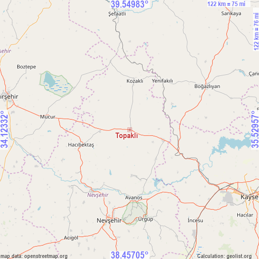
Topaklı GPS coordinates[2]
39° 0' 19.98" North, 34° 49' 35.184" East
| Map corner | latitude | longitude |
|---|---|---|
| Upper-left | 39.54983°, | 34.12332° |
| Center: | 39.00555°, | 34.82644° |
| Lower-right: | 38.45705°, | 35.52957° |
| Map W x H: | 121.5×121.5 km | = 75.5×75.5mi |
| max Lat: | 42.02683° ⇑45.4% North |
| Topaklı: | 39.00555° |
| min Lat: | ⇓54.6% South 35.9025° |
| min Long | Topaklı | max Long |
| 25.90902° | 34.82644° | 44.60099° |
| W 44.9%⇐ | ⇒55.1% E |
Elevation
Elevation of Topaklı is 1206 m = 3957 ft, and this is 488.6 m = 1603 ft above average elevation for this country.
| Max E: |
2682 m = 8799 ft | 19.4% |
| Topaklı | 1206 m 3957 ft | |
| Avg. | 717.4 m = 2354 ft | |
Min E: |
0 m = 0 ft | 80.6% |
See also: Turkey elevation on elevation.city.
Geographical zone
Topaklı is located in North temperate zone (between Tropic of Cancer and the Arctic Circle). Distance of this Northern Tropic circle is 1731.1 km =1075.7 mi to South.| Distance of | km | miles | from Topaklı |
|---|---|---|---|
| North Pole | 5670.1 | 3523.2 | to North |
| Arctic Circle | 3064.2 | 1904 | to North |
| Tropic Cancer | 1731.1 | 1075.7 | to South |
| Equator | 4337 | 2694.9 | to South |


Nearby cities:
15 places around Topaklı: (largest is in red/bold)
• Avanos
32.4 km =20.1 mi,  176°
176°
• Boğazlıyan
41.5 km =25.8 mi,  60°
60°
• Göreme
40.2 km =25 mi, 178°
• Gülşehir
33.7 km =20.9 mi,  211°
211°
• Hacıbektaş
24.3 km =15.1 mi,  252°
252°
• Himmetdede
25.6 km =15.9 mi,  114°
114°
• Karahasanlı
33.6 km =20.9 mi,  344°
344°
• Kozaklı
24.1 km =15 mi,  4°
4°
• Mucur
38.8 km =24.1 mi,  279°
279°
• Nevşehir
43.5 km =27 mi,  193°
193°
• Salanda
32.4 km =20.1 mi,  231°
231°
• Yenifakılı
27.4 km =17 mi,  33°
33°
• Özonak
21.5 km =13.4 mi, 176°
• Ürgüp
42.5 km =26.4 mi,  169°
169°
• İncesu
52.6 km =32.7 mi,  144°
144°
Sources, notices
• [Note1] Compared only with cities in Turkey existing in our database
• [Src1] Map data: © OpenStreetMap contributors (CC-BY-SA)
• [Src2] Other city data from geonames.org with taken over terms of usage.
• [Src3] Geographical zone / Annual Mean Temperature by Robert A. Rohde @ Wikipedia
