Yozgat geodata
Yozgat is a seat of a first-order administrative division; located in Turkey in Europe/Istanbul (GMT+3) time zone. With population of 87,881 people, there are 102 cities with bigger population in this country. Compared to other cities in Turkey, 66.2% of cities are located further ↓South; 55.2% of cities are located further →East and 84.2% of cities have lower elevation than Yozgat. Note1


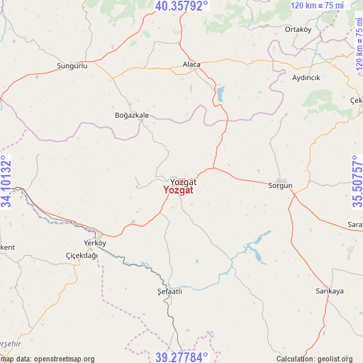
Yozgat GPS coordinates[2]
39° 49' 12" North, 34° 48' 15.984" East
| Map corner | latitude | longitude |
|---|---|---|
| Upper-left | 40.35792°, | 34.10132° |
| Center: | 39.82°, | 34.80444° |
| Lower-right: | 39.27784°, | 35.50757° |
| Map W x H: | 120.1×120.1 km | = 74.6×74.6mi |
| max Lat: | 42.02683° ⇑33.8% North |
| Yozgat: | 39.82° |
| min Lat: | ⇓66.2% South 35.9025° |
| min Long | Yozgat | max Long |
| 25.90902° | 34.80444° | 44.60099° |
| W 44.8%⇐ | ⇒55.2% E |
Elevation
Elevation of Yozgat is 1290 m = 4232 ft, and this is 572.6 m = 1879 ft above average elevation for this country.
| Max E: |
2682 m = 8799 ft | 15.8% |
| Yozgat | 1290 m 4232 ft | |
| Avg. | 717.4 m = 2354 ft | |
Min E: |
0 m = 0 ft | 84.2% |
See also: Yozgat elevation on elevation.city.
Geographical zone
Yozgat is located in North temperate zone (between Tropic of Cancer and the Arctic Circle). Distance of this Northern Tropic circle is 1821.6 km =1131.9 mi to South.| Distance of | km | miles | from Yozgat |
|---|---|---|---|
| North Pole | 5579.5 | 3466.9 | to North |
| Arctic Circle | 2973.6 | 1847.7 | to North |
| Tropic Cancer | 1821.6 | 1131.9 | to South |
| Equator | 4427.6 | 2751.2 | to South |


Nearby cities:
15 places around Yozgat: (largest is in red/bold)
• Alaca
38.9 km =24.2 mi,  4°
4°
• Aydıncık
53.5 km =33.2 mi,  50°
50°
• Boğazkale
27.9 km =17.3 mi,  323°
323°
• Eymir
40.9 km =25.4 mi,  57°
57°
• Göllü
59.7 km =37.1 mi,  226°
226°
• Karahasanlı
58.6 km =36.4 mi,  186°
186°
• Musabeyli
15.6 km =9.7 mi,  275°
275°
• Osmanpaşa
25.7 km =16 mi,  147°
147°
• Salmanlı
47.8 km =29.7 mi, 281°
• Sorgun
32.6 km =20.3 mi,  91°
91°
• Sungurlu
53.3 km =33.1 mi, 316°
• Yenipazar
46.3 km =28.8 mi, 148°
• Yerköy
35.2 km =21.9 mi, 234°
• Çiçekdağı
41.3 km =25.7 mi,  235°
235°
• Şefaatlı
35.3 km =21.9 mi, 186°
Sources, notices
• [Note1] Compared only with cities in Turkey existing in our database
• [Src1] Map data: © OpenStreetMap contributors (CC-BY-SA)
• [Src2] Other city data from geonames.org with taken over terms of usage.
• [Src3] Geographical zone / Annual Mean Temperature by Robert A. Rohde @ Wikipedia
