Çayıralan geodata
Çayıralan (Yozgat) is a seat of a second-order administrative division; located in Turkey in Europe/Istanbul (GMT+3) time zone. With population of 14,734 people, there are 396 cities with bigger population in this country. Compared to other cities in Turkey, 59% of cities are located further ↓South; 51.3% of cities are located further →East and 86.3% of cities have lower elevation than Çayıralan. Note1


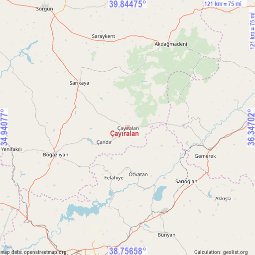
Çayıralan GPS coordinates[2]
39° 18' 10.008" North, 35° 38' 38.004" East
| Map corner | latitude | longitude |
|---|---|---|
| Upper-left | 39.84475°, | 34.94077° |
| Center: | 39.30278°, | 35.64389° |
| Lower-right: | 38.75658°, | 36.34702° |
| Map W x H: | 121×121 km | = 75.2×75.2mi |
| max Lat: | 42.02683° ⇑41% North |
| Çayıralan: | 39.30278° |
| min Lat: | ⇓59% South 35.9025° |
| min Long | Çayıralan | max Long |
| 25.90902° | 35.64389° | 44.60099° |
| W 48.7%⇐ | ⇒51.3% E |
Elevation
Elevation of Çayıralan is 1350 m = 4429 ft, and this is 632.6 m = 2075 ft above average elevation for this country.
| Max E: |
2682 m = 8799 ft | 13.7% |
| Çayıralan | 1350 m 4429 ft | |
| Avg. | 717.4 m = 2354 ft | |
Min E: |
0 m = 0 ft | 86.3% |
See also: Turkey elevation on elevation.city.
Geographical zone
Çayıralan is located in North temperate zone (between Tropic of Cancer and the Arctic Circle). Distance of this Northern Tropic circle is 1764.1 km =1096.2 mi to South.| Distance of | km | miles | from Çayıralan |
|---|---|---|---|
| North Pole | 5637 | 3502.7 | to North |
| Arctic Circle | 3031.1 | 1883.4 | to North |
| Tropic Cancer | 1764.1 | 1096.2 | to South |
| Equator | 4370.1 | 2715.5 | to South |


Nearby cities:
15 places around Çayıralan: (largest is in red/bold)
• Akdağmadeni
44.8 km =27.8 mi,  27°
27°
• Boğazlıyan
36.6 km =22.7 mi,  249°
249°
• Bünyan
54.1 km =33.6 mi,  159°
159°
• Felahiye
24.5 km =15.2 mi,  195°
195°
• Gemerek
39.2 km =24.4 mi,  109°
109°
• Hasbek
28.6 km =17.8 mi,  343°
343°
• Muncusun
44.5 km =27.7 mi,  181°
181°
• Ortaköy
52.4 km =32.6 mi,  75°
75°
• Saraykent
44.9 km =27.9 mi,  345°
345°
• Sarıkaya
31.2 km =19.4 mi,  312°
312°
• Sarıoğlan
37.5 km =23.3 mi,  132°
132°
• Yenifakılı
56.3 km =35 mi,  259°
259°
• Yenipazar
51.4 km =31.9 mi,  290°
290°
• Çandır
12.9 km =8 mi,  239°
239°
• Özvatan
22.3 km =13.9 mi,  167°
167°
Sources, notices
• [Note1] Compared only with cities in Turkey existing in our database
• [Src1] Map data: © OpenStreetMap contributors (CC-BY-SA)
• [Src2] Other city data from geonames.org with taken over terms of usage.
• [Src3] Geographical zone / Annual Mean Temperature by Robert A. Rohde @ Wikipedia
