Sarıkaya geodata
Sarıkaya (Yozgat) is a seat of a second-order administrative division; located in Turkey in Europe/Istanbul (GMT+3) time zone. In our database, there are 1323 cities with bigger population. Compared to other cities in Turkey, 61.2% of cities are located further ↓South; 52.6% of cities are located further →East and 75.6% of cities have lower elevation than Sarıkaya. Note1


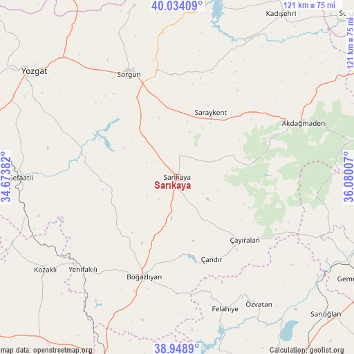
Sarıkaya GPS coordinates[2]
39° 29' 36.996" North, 35° 22' 36.984" East
| Map corner | latitude | longitude |
|---|---|---|
| Upper-left | 40.03409°, | 34.67382° |
| Center: | 39.49361°, | 35.37694° |
| Lower-right: | 38.9489°, | 36.08007° |
| Map W x H: | 120.7×120.7 km | = 75×75mi |
| max Lat: | 42.02683° ⇑38.8% North |
| Sarıkaya: | 39.49361° |
| min Lat: | ⇓61.2% South 35.9025° |
| min Long | Sarıkaya | max Long |
| 25.90902° | 35.37694° | 44.60099° |
| W 47.4%⇐ | ⇒52.6% E |
Elevation
Elevation of Sarıkaya is 1115 m = 3658 ft, and this is 397.6 m = 1304 ft above average elevation for this country.
| Max E: |
2682 m = 8799 ft | 24.4% |
| Sarıkaya | 1115 m 3658 ft | |
| Avg. | 717.4 m = 2354 ft | |
Min E: |
0 m = 0 ft | 75.6% |
See also: Turkey elevation on elevation.city.
Geographical zone
Sarıkaya is located in North temperate zone (between Tropic of Cancer and the Arctic Circle). Distance of this Northern Tropic circle is 1785.4 km =1109.4 mi to South.| Distance of | km | miles | from Sarıkaya |
|---|---|---|---|
| North Pole | 5615.8 | 3489.5 | to North |
| Arctic Circle | 3009.9 | 1870.3 | to North |
| Tropic Cancer | 1785.4 | 1109.4 | to South |
| Equator | 4391.3 | 2728.6 | to South |


Nearby cities:
15 places around Sarıkaya: (largest is in red/bold)
• Akdağmadeni
47.2 km =29.3 mi,  66°
66°
• Boğazlıyan
35.7 km =22.2 mi,  198°
198°
• Eymir
60.2 km =37.4 mi,  346°
346°
• Felahiye
47.7 km =29.6 mi,  159°
159°
• Hasbek
15.9 km =9.9 mi, 67°
• Kozaklı
54.4 km =33.8 mi,  236°
236°
• Osmanpaşa
38.2 km =23.7 mi,  292°
292°
• Saraykent
25 km =15.5 mi,  27°
27°
• Sorgun
38.8 km =24.1 mi,  335°
335°
• Yenifakılı
45.1 km =28 mi,  225°
225°
• Yenipazar
25.4 km =15.8 mi,  262°
262°
• Çandır
30.1 km =18.7 mi, 156°
• Çayıralan
31.2 km =19.4 mi,  132°
132°
• Özvatan
51.2 km =31.8 mi,  147°
147°
• Şefaatlı
53.3 km =33.1 mi,  271°
271°
Sources, notices
• [Note1] Compared only with cities in Turkey existing in our database
• [Src1] Map data: © OpenStreetMap contributors (CC-BY-SA)
• [Src2] Other city data from geonames.org with taken over terms of usage.
• [Src3] Geographical zone / Annual Mean Temperature by Robert A. Rohde @ Wikipedia
