Osmanpaşa geodata
Osmanpaşa (Yozgat) is a seat of a third-order administrative division; located in Turkey in Europe/Istanbul (GMT+3) time zone. In our database, there are 1323 cities with bigger population. Compared to other cities in Turkey, 63.4% of cities are located further ↓South; 54.4% of cities are located further →East and 71.5% of cities have lower elevation than Osmanpaşa. Note1


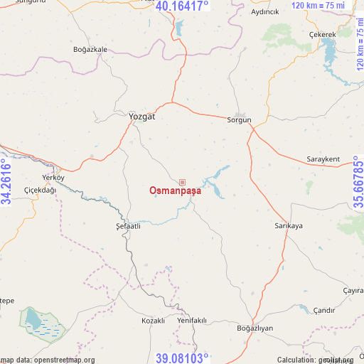
Osmanpaşa GPS coordinates[2]
39° 37' 28.992" North, 34° 57' 52.992" East
| Map corner | latitude | longitude |
|---|---|---|
| Upper-left | 40.16417°, | 34.2616° |
| Center: | 39.62472°, | 34.96472° |
| Lower-right: | 39.08103°, | 35.66785° |
| Map W x H: | 120.4×120.4 km | = 74.8×74.8mi |
| max Lat: | 42.02683° ⇑36.6% North |
| Osmanpaşa: | 39.62472° |
| min Lat: | ⇓63.4% South 35.9025° |
| min Long | Osmanpaşa | max Long |
| 25.90902° | 34.96472° | 44.60099° |
| W 45.6%⇐ | ⇒54.4% E |
Elevation
Elevation of Osmanpaşa is 1049 m = 3442 ft, and this is 331.6 m = 1088 ft above average elevation for this country.
| Max E: |
2682 m = 8799 ft | 28.5% |
| Osmanpaşa | 1049 m 3442 ft | |
| Avg. | 717.4 m = 2354 ft | |
Min E: |
0 m = 0 ft | 71.5% |
See also: Turkey elevation on elevation.city.
Geographical zone
Osmanpaşa is located in North temperate zone (between Tropic of Cancer and the Arctic Circle). Distance of this Northern Tropic circle is 1799.9 km =1118.4 mi to South.| Distance of | km | miles | from Osmanpaşa |
|---|---|---|---|
| North Pole | 5601.2 | 3480.4 | to North |
| Arctic Circle | 2995.3 | 1861.2 | to North |
| Tropic Cancer | 1799.9 | 1118.4 | to South |
| Equator | 4405.9 | 2737.7 | to South |


Nearby cities:
15 places around Osmanpaşa: (largest is in red/bold)
• Boğazkale
53.6 km =33.3 mi,  325°
325°
• Eymir
48.5 km =30.1 mi,  25°
25°
• Hasbek
50.7 km =31.5 mi,  99°
99°
• Karahasanlı
42 km =26.1 mi,  209°
209°
• Kozaklı
45.9 km =28.5 mi,  192°
192°
• Musabeyli
37.3 km =23.2 mi,  308°
308°
• Saraykent
47.4 km =29.5 mi,  80°
80°
• Sarıkaya
38.2 km =23.7 mi,  112°
112°
• Sorgun
28 km =17.4 mi,  42°
42°
• Yenifakılı
46.1 km =28.6 mi,  176°
176°
• Yenipazar
20.6 km =12.8 mi,  150°
150°
• Yerköy
42.6 km =26.5 mi,  271°
271°
• Yozgat
25.7 km =16 mi, 327°
• Çiçekdağı
47.7 km =29.6 mi, 267°
• Şefaatlı
22.3 km =13.9 mi,  233°
233°
Sources, notices
• [Note1] Compared only with cities in Turkey existing in our database
• [Src1] Map data: © OpenStreetMap contributors (CC-BY-SA)
• [Src2] Other city data from geonames.org with taken over terms of usage.
• [Src3] Geographical zone / Annual Mean Temperature by Robert A. Rohde @ Wikipedia
