Yenice geodata
Yenice (Canakkale) is a seat of a second-order administrative division; located in Turkey in Europe/Istanbul (GMT+3) time zone. In our database, there are 1323 cities with bigger population. Compared to other cities in Turkey, 68.1% of cities are located further ↓South; 95.2% of cities are located further →East and 70.5% of cities have higher elevation than Yenice. Note1


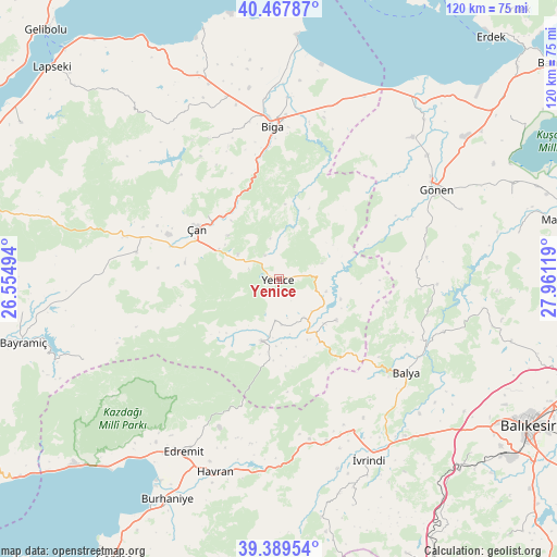
Yenice GPS coordinates[2]
39° 55' 50.988" North, 27° 15' 29.016" East
| Map corner | latitude | longitude |
|---|---|---|
| Upper-left | 40.46787°, | 26.55494° |
| Center: | 39.93083°, | 27.25806° |
| Lower-right: | 39.38954°, | 27.96119° |
| Map W x H: | 119.9×119.9 km | = 74.5×74.5mi |
| max Lat: | 42.02683° ⇑31.9% North |
| Yenice: | 39.93083° |
| min Lat: | ⇓68.1% South 35.9025° |
| min Long | Yenice | max Long |
| 25.90902° | 27.25806° | 44.60099° |
| W 4.8%⇐ | ⇒95.2% E |
Elevation
Elevation of Yenice is 274 m = 899 ft, and this is 443.4 m = 1455 ft below average elevation for this country.
| Max E: |
2682 m = 8799 ft | 70.5% |
| Avg. | 717.4 m = 2354 ft | |
| Yenice | 274 m = 899 ft | |
Min E: |
0 m = 0 ft | 29.5% |
See also: Turkey elevation on elevation.city.
Geographical zone
Yenice is located in North temperate zone (between Tropic of Cancer and the Arctic Circle). Distance of this Northern Tropic circle is 1834 km =1139.6 mi to South.| Distance of | km | miles | from Yenice |
|---|---|---|---|
| North Pole | 5567.2 | 3459.3 | to North |
| Arctic Circle | 2961.3 | 1840.1 | to North |
| Tropic Cancer | 1834 | 1139.6 | to South |
| Equator | 4439.9 | 2758.8 | to South |


Nearby cities:
15 places around Yenice: (largest is in red/bold)
• Bakacak
33.9 km =21.1 mi,  333°
333°
• Balya
34.1 km =21.2 mi,  126°
126°
• Biga
33.1 km =20.6 mi,  357°
357°
• Danişment
32.7 km =20.3 mi,  102°
102°
• Dimetoka
39.1 km =24.3 mi,  2°
2°
• Etili
31.4 km =19.5 mi,  281°
281°
• Gönen
38.9 km =24.2 mi,  60°
60°
• Gündoğdu
39.6 km =24.6 mi,  339°
339°
• Hamdibey
9.1 km =5.7 mi,  185°
185°
• Kalkım
13.7 km =8.5 mi,  195°
195°
• Pazarköy
15.1 km =9.4 mi,  124°
124°
• Sarıköy
42.1 km =26.2 mi,  43°
43°
• Sinekçi
39.9 km =24.8 mi,  18°
18°
• Tütüncü
42.1 km =26.2 mi,  68°
68°
• Çan
20.9 km =13 mi,  303°
303°
Sources, notices
• [Note1] Compared only with cities in Turkey existing in our database
• [Src1] Map data: © OpenStreetMap contributors (CC-BY-SA)
• [Src2] Other city data from geonames.org with taken over terms of usage.
• [Src3] Geographical zone / Annual Mean Temperature by Robert A. Rohde @ Wikipedia
