Gündoğdu geodata
Gündoğdu (Canakkale) is a seat of a third-order administrative division; located in Turkey in Europe/Istanbul (GMT+3) time zone. In our database, there are 1323 cities with bigger population. Compared to other cities in Turkey, 73.8% of cities are located further ↓South; 96.5% of cities are located further →East and 88.7% of cities have higher elevation than Gündoğdu. Note1


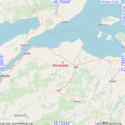
Gündoğdu GPS coordinates[2]
40° 15' 50.688" North, 27° 5' 34.368" East
| Map corner | latitude | longitude |
|---|---|---|
| Upper-left | 40.79849°, | 26.38976° |
| Center: | 40.26408°, | 27.09288° |
| Lower-right: | 39.72542°, | 27.79601° |
| Map W x H: | 119.3×119.3 km | = 74.1×74.1mi |
| max Lat: | 42.02683° ⇑26.2% North |
| Gündoğdu: | 40.26408° |
| min Lat: | ⇓73.8% South 35.9025° |
| min Long | Gündoğdu | max Long |
| 25.90902° | 27.09288° | 44.60099° |
| W 3.5%⇐ | ⇒96.5% E |
Elevation
Elevation of Gündoğdu is 46 m = 151 ft, and this is 671.4 m = 2203 ft below average elevation for this country.
| Max E: |
2682 m = 8799 ft | 88.7% |
| Avg. | 717.4 m = 2354 ft | |
| Gündoğdu | 46 m = 151 ft | |
Min E: |
0 m = 0 ft | 11.3% |
See also: Turkey elevation on elevation.city.
Geographical zone
Gündoğdu is located in North temperate zone (between Tropic of Cancer and the Arctic Circle). Distance of this Northern Tropic circle is 1871 km =1162.6 mi to South.| Distance of | km | miles | from Gündoğdu |
|---|---|---|---|
| North Pole | 5530.1 | 3436.2 | to North |
| Arctic Circle | 2924.2 | 1817 | to North |
| Tropic Cancer | 1871 | 1162.6 | to South |
| Equator | 4476.9 | 2781.8 | to South |


Nearby cities:
15 places around Gündoğdu: (largest is in red/bold)
• Bakacak
6.6 km =4.1 mi,  187°
187°
• Balıklıçeşme
5.2 km =3.2 mi,  349°
349°
• Beyçayırı
14.3 km =8.9 mi,  266°
266°
• Biga
13.3 km =8.3 mi,  107°
107°
• Bolayır
39.9 km =24.8 mi,  314°
314°
• Dimetoka
16.2 km =10.1 mi,  82°
82°
• Etili
35.2 km =21.9 mi,  208°
208°
• Gelibolu
39.3 km =24.4 mi,  294°
294°
• Karabiga
23.7 km =14.7 mi,  49°
49°
• Lapseki
35.7 km =22.2 mi,  284°
284°
• Sinekçi
26.6 km =16.5 mi,  88°
88°
• Umurbey
41.4 km =25.7 mi, 265°
• Yenice
39.6 km =24.6 mi,  159°
159°
• Çan
25.9 km =16.1 mi, 187°
• Şarköy
38.9 km =24.2 mi,  2°
2°
Sources, notices
• [Note1] Compared only with cities in Turkey existing in our database
• [Src1] Map data: © OpenStreetMap contributors (CC-BY-SA)
• [Src2] Other city data from geonames.org with taken over terms of usage.
• [Src3] Geographical zone / Annual Mean Temperature by Robert A. Rohde @ Wikipedia
