Yağcılar geodata
Yağcılar (Balıkesir) is a seat of a third-order administrative division; located in Turkey in Europe/Istanbul (GMT+3) time zone. In our database, there are 1323 cities with bigger population. Compared to other cities in Turkey, 60% of cities are located further ↓South; 87.6% of cities are located further →East and 67.5% of cities have higher elevation than Yağcılar. Note1


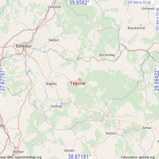
Yağcılar GPS coordinates[2]
39° 25' 1.632" North, 28° 22' 51.924" East
| Map corner | latitude | longitude |
|---|---|---|
| Upper-left | 39.9582°, | 27.67797° |
| Center: | 39.41712°, | 28.38109° |
| Lower-right: | 38.87181°, | 29.08422° |
| Map W x H: | 120.8×120.8 km | = 75.1×75.1mi |
| max Lat: | 42.02683° ⇑40% North |
| Yağcılar: | 39.41712° |
| min Lat: | ⇓60% South 35.9025° |
| min Long | Yağcılar | max Long |
| 25.90902° | 28.38109° | 44.60099° |
| W 12.4%⇐ | ⇒87.6% E |
Elevation
Elevation of Yağcılar is 364 m = 1194 ft, and this is 353.4 m = 1159 ft below average elevation for this country.
| Max E: |
2682 m = 8799 ft | 67.5% |
| Avg. | 717.4 m = 2354 ft | |
| Yağcılar | 364 m = 1194 ft | |
Min E: |
0 m = 0 ft | 32.5% |
See also: Turkey elevation on elevation.city.
Geographical zone
Yağcılar is located in North temperate zone (between Tropic of Cancer and the Arctic Circle). Distance of this Northern Tropic circle is 1776.9 km =1104.1 mi to South.| Distance of | km | miles | from Yağcılar |
|---|---|---|---|
| North Pole | 5624.3 | 3494.8 | to North |
| Arctic Circle | 3018.4 | 1875.5 | to North |
| Tropic Cancer | 1776.9 | 1104.1 | to South |
| Equator | 4382.8 | 2723.3 | to South |


Nearby cities:
15 places around Yağcılar: (largest is in red/bold)
• Balıkesir
49.7 km =30.9 mi,  301°
301°
• Bigadiç
21.7 km =13.5 mi,  262°
262°
• Demirci
47.7 km =29.6 mi,  149°
149°
• Durak
33.5 km =20.8 mi,  343°
343°
• Dursunbey
28.2 km =17.5 mi,  48°
48°
• Düvertepe
20.6 km =12.8 mi,  165°
165°
• Gökçedağ
48.8 km =30.3 mi,  71°
71°
• Gölcük
36.1 km =22.4 mi,  251°
251°
• Kavacık
30.3 km =18.8 mi,  18°
18°
• Kepsut
36 km =22.4 mi,  327°
327°
• Kireç
15.4 km =9.6 mi,  354°
354°
• Konakpınar
46.8 km =29.1 mi,  272°
272°
• Sındırgı
26.2 km =16.3 mi,  221°
221°
• Yeniköy
51.6 km =32.1 mi,  321°
321°
• Çağış
33.6 km =20.9 mi,  289°
289°
Sources, notices
• [Note1] Compared only with cities in Turkey existing in our database
• [Src1] Map data: © OpenStreetMap contributors (CC-BY-SA)
• [Src2] Other city data from geonames.org with taken over terms of usage.
• [Src3] Geographical zone / Annual Mean Temperature by Robert A. Rohde @ Wikipedia
