Sındırgı geodata
Sındırgı (Balıkesir) is a seat of a second-order administrative division; located in Turkey in Europe/Istanbul (GMT+3) time zone. With population of 10,907 people, there are 489 cities with bigger population in this country. Compared to other cities in Turkey, 58.1% of cities are located further ↓South; 88.9% of cities are located further →East and 72.7% of cities have higher elevation than Sındırgı. Note1


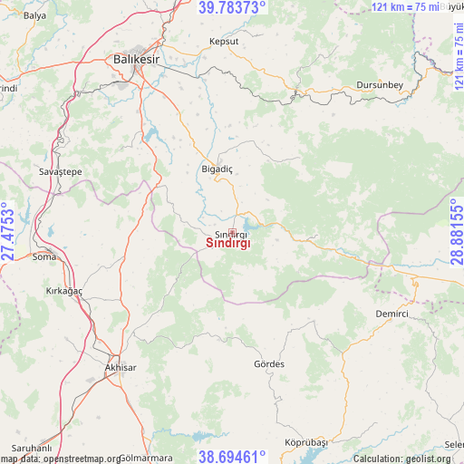
Sındırgı GPS coordinates[2]
39° 14' 28.608" North, 28° 10' 42.312" East
| Map corner | latitude | longitude |
|---|---|---|
| Upper-left | 39.78373°, | 27.4753° |
| Center: | 39.24128°, | 28.17842° |
| Lower-right: | 38.69461°, | 28.88155° |
| Map W x H: | 121.1×121.1 km | = 75.2×75.2mi |
| max Lat: | 42.02683° ⇑41.9% North |
| Sındırgı: | 39.24128° |
| min Lat: | ⇓58.1% South 35.9025° |
| min Long | Sındırgı | max Long |
| 25.90902° | 28.17842° | 44.60099° |
| W 11.1%⇐ | ⇒88.9% E |
Elevation
Elevation of Sındırgı is 220 m = 722 ft, and this is 497.4 m = 1632 ft below average elevation for this country.
| Max E: |
2682 m = 8799 ft | 72.7% |
| Avg. | 717.4 m = 2354 ft | |
| Sındırgı | 220 m = 722 ft | |
Min E: |
0 m = 0 ft | 27.3% |
See also: Turkey elevation on elevation.city.
Geographical zone
Sındırgı is located in North temperate zone (between Tropic of Cancer and the Arctic Circle). Distance of this Northern Tropic circle is 1757.3 km =1091.9 mi to South.| Distance of | km | miles | from Sındırgı |
|---|---|---|---|
| North Pole | 5643.8 | 3506.9 | to North |
| Arctic Circle | 3038 | 1887.7 | to North |
| Tropic Cancer | 1757.3 | 1091.9 | to South |
| Equator | 4363.2 | 2711.2 | to South |


Nearby cities:
15 places around Sındırgı: (largest is in red/bold)
• Akhisar
46.3 km =28.8 mi,  219°
219°
• Bigadiç
17.3 km =10.7 mi,  346°
346°
• Demirci
46.8 km =29.1 mi,  117°
117°
• Düvertepe
22.5 km =14 mi,  91°
91°
• Gelembe
29.3 km =18.2 mi,  256°
256°
• Gölcük
18.6 km =11.6 mi,  295°
295°
• Gördes
35.6 km =22.1 mi,  164°
164°
• Kepsut
49.8 km =30.9 mi,  357°
357°
• Kireç
38.4 km =23.9 mi,  24°
24°
• Konakpınar
36.4 km =22.6 mi,  306°
306°
• Kırkağaç
46.4 km =28.8 mi,  251°
251°
• Savaştepe
47.6 km =29.6 mi,  289°
289°
• Soma
49.4 km =30.7 mi, 262°
• Yağcılar
26.2 km =16.3 mi,  41°
41°
• Çağış
34 km =21.1 mi,  335°
335°
Sources, notices
• [Note1] Compared only with cities in Turkey existing in our database
• [Src1] Map data: © OpenStreetMap contributors (CC-BY-SA)
• [Src2] Other city data from geonames.org with taken over terms of usage.
• [Src3] Geographical zone / Annual Mean Temperature by Robert A. Rohde @ Wikipedia
