Düvertepe geodata
Düvertepe (Balıkesir) is a seat of a third-order administrative division; located in Turkey in Europe/Istanbul (GMT+3) time zone. In our database, there are 1323 cities with bigger population. Compared to other cities in Turkey, 58.1% of cities are located further ↓South; 87.4% of cities are located further →East and 51.4% of cities have lower elevation than Düvertepe. Note1


Düvertepe GPS coordinates[2]
39° 14' 14.424" North, 28° 26' 24.036" East
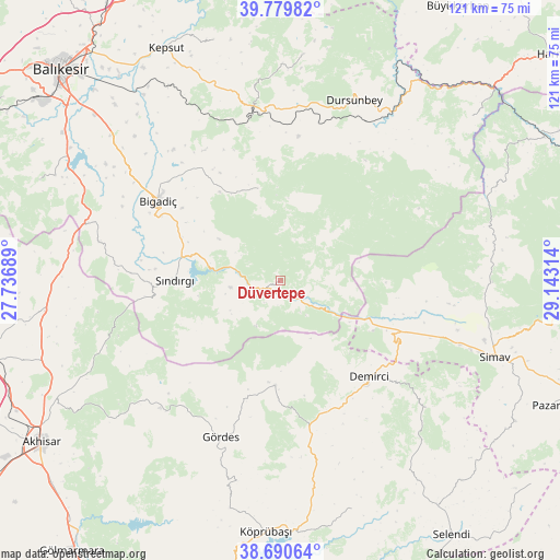
| Map corner | latitude | longitude |
|---|---|---|
| Upper-left | 39.77982°, | 27.73689° |
| Center: | 39.23734°, | 28.44001° |
| Lower-right: | 38.69064°, | 29.14314° |
| Map W x H: | 121.1×121.1 km | = 75.2×75.2mi |
| max Lat: | 42.02683° ⇑41.9% North |
| Düvertepe: | 39.23734° |
| min Lat: | ⇓58.1% South 35.9025° |
| min Long | Düvertepe | max Long |
| 25.90902° | 28.44001° | 44.60099° |
| W 12.6%⇐ | ⇒87.4% E |
Elevation
Elevation of Düvertepe is 726 m = 2382 ft, and this is 8.6 m = 28 ft above average elevation for this country.
| Max E: |
2682 m = 8799 ft | 48.6% |
| Düvertepe | 726 m 2382 ft | |
| Avg. | 717.4 m = 2354 ft | |
Min E: |
0 m = 0 ft | 51.4% |
See also: Turkey elevation on elevation.city.
Geographical zone
Düvertepe is located in North temperate zone (between Tropic of Cancer and the Arctic Circle). Distance of this Northern Tropic circle is 1756.9 km =1091.7 mi to South.| Distance of | km | miles | from Düvertepe |
|---|---|---|---|
| North Pole | 5644.3 | 3507.2 | to North |
| Arctic Circle | 3038.4 | 1888 | to North |
| Tropic Cancer | 1756.9 | 1091.7 | to South |
| Equator | 4362.8 | 2710.9 | to South |


Nearby cities:
15 places around Düvertepe: (largest is in red/bold)
• Bigadiç
31.7 km =19.7 mi,  302°
302°
• Borlu
53.9 km =33.5 mi,  177°
177°
• Dağardı
52.4 km =32.6 mi,  65°
65°
• Demirci
28.4 km =17.6 mi,  138°
138°
• Dursunbey
41.9 km =26 mi,  22°
22°
• Gelembe
51.4 km =31.9 mi,  262°
262°
• Gölcük
40.2 km =25 mi,  282°
282°
• Gördes
36.3 km =22.6 mi,  200°
200°
• Kavacık
48.9 km =30.4 mi,  5°
5°
• Kireç
35.9 km =22.3 mi,  349°
349°
• Simav
49.2 km =30.6 mi,  109°
109°
• Sındırgı
22.5 km =14 mi,  271°
271°
• Yarbasan
42.1 km =26.2 mi,  131°
131°
• Yağcılar
20.6 km =12.8 mi, 345°
• Çağış
48.3 km =30 mi,  310°
310°
Sources, notices
• [Note1] Compared only with cities in Turkey existing in our database
• [Src1] Map data: © OpenStreetMap contributors (CC-BY-SA)
• [Src2] Other city data from geonames.org with taken over terms of usage.
• [Src3] Geographical zone / Annual Mean Temperature by Robert A. Rohde @ Wikipedia
