Tekman geodata
Tekman (Erzurum) is a seat of a second-order administrative division; located in Turkey in Europe/Istanbul (GMT+3) time zone. With population of 8,270 people, there are 567 cities with bigger population in this country. Compared to other cities in Turkey, 63.7% of cities are located further ↓South; 86.3% of cities are located further ←West and 98.3% of cities have lower elevation than Tekman. Note1


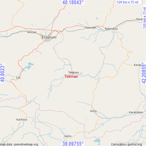
Tekman GPS coordinates[2]
39° 38' 27.996" North, 41° 30' 19.512" East
| Map corner | latitude | longitude |
|---|---|---|
| Upper-left | 40.18043°, | 40.8023° |
| Center: | 39.64111°, | 41.50542° |
| Lower-right: | 39.09755°, | 42.20855° |
| Map W x H: | 120.4×120.4 km | = 74.8×74.8mi |
| max Lat: | 42.02683° ⇑36.3% North |
| Tekman: | 39.64111° |
| min Lat: | ⇓63.7% South 35.9025° |
| min Long | Tekman | max Long |
| 25.90902° | 41.50542° | 44.60099° |
| W 86.3%⇐ | ⇒13.7% E |
Elevation
Elevation of Tekman is 1905 m = 6250 ft, and this is 1187.6 m = 3896 ft above average elevation for this country.
| Max E: |
2682 m = 8799 ft | 1.7% |
| Tekman | 1905 m 6250 ft | |
| Avg. | 717.4 m = 2354 ft | |
Min E: |
0 m = 0 ft | 98.3% |
See also: Turkey elevation on elevation.city.
Geographical zone
Tekman is located in North temperate zone (between Tropic of Cancer and the Arctic Circle). Distance of this Northern Tropic circle is 1801.8 km =1119.6 mi to South.| Distance of | km | miles | from Tekman |
|---|---|---|---|
| North Pole | 5599.4 | 3479.3 | to North |
| Arctic Circle | 2993.5 | 1860.1 | to North |
| Tropic Cancer | 1801.8 | 1119.6 | to South |
| Equator | 4407.7 | 2738.8 | to South |


Nearby cities:
15 places around Tekman: (largest is in red/bold)
• Dadaşköy
40 km =24.9 mi,  327°
327°
• Dumlu
48.1 km =29.9 mi,  344°
344°
• Erzurum
35.6 km =22.1 mi, 326°
• Gökoğlan
20.2 km =12.6 mi,  238°
238°
• Halilçavuş
50.3 km =31.3 mi,  150°
150°
• Hınıs
35.4 km =22 mi, 153°
• Ilıca
48.8 km =30.3 mi,  314°
314°
• Kazımkarabekir
36.1 km =22.4 mi, 327°
• Köprüköy
47.6 km =29.6 mi,  40°
40°
• Palandöken
33.6 km =20.9 mi, 325°
• Pasinler
40.2 km =25 mi,  20°
20°
• Söylemez
28.6 km =17.8 mi,  62°
62°
• Yakutiye
35 km =21.7 mi,  324°
324°
• Çat
46.2 km =28.7 mi,  265°
265°
• Çaylar
45.7 km =28.4 mi,  204°
204°
Sources, notices
• [Note1] Compared only with cities in Turkey existing in our database
• [Src1] Map data: © OpenStreetMap contributors (CC-BY-SA)
• [Src2] Other city data from geonames.org with taken over terms of usage.
• [Src3] Geographical zone / Annual Mean Temperature by Robert A. Rohde @ Wikipedia
