Gökoğlan geodata
Gökoğlan (Erzurum) is a seat of a third-order administrative division; located in Turkey in Europe/Istanbul (GMT+3) time zone. In our database, there are 1323 cities with bigger population. Compared to other cities in Turkey, 61.9% of cities are located further ↓South; 84.3% of cities are located further ←West and 99.6% of cities have lower elevation than Gökoğlan. Note1


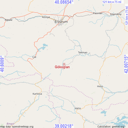
Gökoğlan GPS coordinates[2]
39° 32' 47.328" North, 41° 18' 14.472" East
| Map corner | latitude | longitude |
|---|---|---|
| Upper-left | 40.08654°, | 40.6009° |
| Center: | 39.54648°, | 41.30402° |
| Lower-right: | 39.00218°, | 42.00715° |
| Map W x H: | 120.6×120.6 km | = 74.9×74.9mi |
| max Lat: | 42.02683° ⇑38.1% North |
| Gökoğlan: | 39.54648° |
| min Lat: | ⇓61.9% South 35.9025° |
| min Long | Gökoğlan | max Long |
| 25.90902° | 41.30402° | 44.60099° |
| W 84.3%⇐ | ⇒15.7% E |
Elevation
Elevation of Gökoğlan is 2112 m = 6929 ft, and this is 1394.6 m = 4575 ft above average elevation for this country.
| Max E: |
2682 m = 8799 ft | 0.40000000000001% |
| Gökoğlan | 2112 m 6929 ft | |
| Avg. | 717.4 m = 2354 ft | |
Min E: |
0 m = 0 ft | 99.6% |
See also: Turkey elevation on elevation.city.
Geographical zone
Gökoğlan is located in North temperate zone (between Tropic of Cancer and the Arctic Circle). Distance of this Northern Tropic circle is 1791.2 km =1113 mi to South.| Distance of | km | miles | from Gökoğlan |
|---|---|---|---|
| North Pole | 5609.9 | 3485.8 | to North |
| Arctic Circle | 3004 | 1866.6 | to North |
| Tropic Cancer | 1791.2 | 1113 | to South |
| Equator | 4397.2 | 2732.3 | to South |


Nearby cities:
15 places around Gökoğlan: (largest is in red/bold)
• Dadaşköy
44.5 km =27.7 mi,  354°
354°
• Erzurum
40.3 km =25 mi,  356°
356°
• Halilçavuş
53.6 km =33.3 mi,  128°
128°
• Hınıs
39.4 km =24.5 mi,  122°
122°
• Ilıca
47.9 km =29.8 mi,  338°
338°
• Kandilli
56.5 km =35.1 mi,  314°
314°
• Karlıova
38.3 km =23.8 mi,  221°
221°
• Kazımkarabekir
41.1 km =25.5 mi, 357°
• Palandöken
38.1 km =23.7 mi, 356°
• Söylemez
48.8 km =30.3 mi,  60°
60°
• Tekman
20.2 km =12.6 mi, 58°
• Varto
43.4 km =27 mi,  162°
162°
• Yakutiye
39.2 km =24.4 mi, 355°
• Çat
29.5 km =18.3 mi,  283°
283°
• Çaylar
31.1 km =19.3 mi,  183°
183°
Sources, notices
• [Note1] Compared only with cities in Turkey existing in our database
• [Src1] Map data: © OpenStreetMap contributors (CC-BY-SA)
• [Src2] Other city data from geonames.org with taken over terms of usage.
• [Src3] Geographical zone / Annual Mean Temperature by Robert A. Rohde @ Wikipedia
