Karlıova geodata
Karlıova (Bingöl) is a seat of a second-order administrative division; located in Turkey in Europe/Istanbul (GMT+3) time zone. With population of 8,801 people, there are 540 cities with bigger population in this country. Compared to other cities in Turkey, 58.9% of cities are located further ↓South; 81.4% of cities are located further ←West and 97.8% of cities have lower elevation than Karlıova. Note1


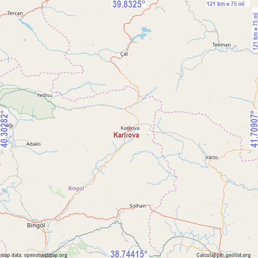
Karlıova GPS coordinates[2]
39° 17' 25.584" North, 41° 0' 21.384" East
| Map corner | latitude | longitude |
|---|---|---|
| Upper-left | 39.8325°, | 40.30282° |
| Center: | 39.29044°, | 41.00594° |
| Lower-right: | 38.74415°, | 41.70907° |
| Map W x H: | 121×121 km | = 75.2×75.2mi |
| max Lat: | 42.02683° ⇑41.1% North |
| Karlıova: | 39.29044° |
| min Lat: | ⇓58.9% South 35.9025° |
| min Long | Karlıova | max Long |
| 25.90902° | 41.00594° | 44.60099° |
| W 81.4%⇐ | ⇒18.6% E |
Elevation
Elevation of Karlıova is 1835 m = 6020 ft, and this is 1117.6 m = 3667 ft above average elevation for this country.
| Max E: |
2682 m = 8799 ft | 2.2% |
| Karlıova | 1835 m 6020 ft | |
| Avg. | 717.4 m = 2354 ft | |
Min E: |
0 m = 0 ft | 97.8% |
See also: Turkey elevation on elevation.city.
Geographical zone
Karlıova is located in North temperate zone (between Tropic of Cancer and the Arctic Circle). Distance of this Northern Tropic circle is 1762.8 km =1095.4 mi to South.| Distance of | km | miles | from Karlıova |
|---|---|---|---|
| North Pole | 5638.4 | 3503.5 | to North |
| Arctic Circle | 3032.5 | 1884.3 | to North |
| Tropic Cancer | 1762.8 | 1095.4 | to South |
| Equator | 4368.7 | 2714.6 | to South |


Nearby cities:
15 places around Karlıova: (largest is in red/bold)
• Adaklı
45.6 km =28.3 mi,  260°
260°
• Gökoğlan
38.3 km =23.8 mi,  41°
41°
• Göynük
20.3 km =12.6 mi,  214°
214°
• Ilıcalar
44.8 km =27.8 mi,  219°
219°
• Kasaba
56.5 km =35.1 mi,  272°
272°
• Mercimekkale
58.8 km =36.5 mi,  133°
133°
• Sancak
57.7 km =35.9 mi,  247°
247°
• Solhan
36.4 km =22.6 mi,  173°
173°
• Tekman
58 km =36 mi,  47°
47°
• Varto
40.7 km =25.3 mi,  108°
108°
• Yaygın
50.8 km =31.6 mi,  149°
149°
• Yedisu
43.6 km =27.1 mi,  291°
291°
• Yenibaşak
54.1 km =33.6 mi,  181°
181°
• Çat
35.3 km =21.9 mi,  354°
354°
• Çaylar
24 km =14.9 mi,  96°
96°
Sources, notices
• [Note1] Compared only with cities in Turkey existing in our database
• [Src1] Map data: © OpenStreetMap contributors (CC-BY-SA)
• [Src2] Other city data from geonames.org with taken over terms of usage.
• [Src3] Geographical zone / Annual Mean Temperature by Robert A. Rohde @ Wikipedia
