Dereova geodata
Dereova (Tunceli) is a seat of a third-order administrative division; located in Turkey in Europe/Istanbul (GMT+3) time zone. In our database, there are 1323 cities with bigger population. Compared to other cities in Turkey, 58.2% of cities are located further ↓South; 73% of cities are located further ←West and 90.1% of cities have lower elevation than Dereova. Note1


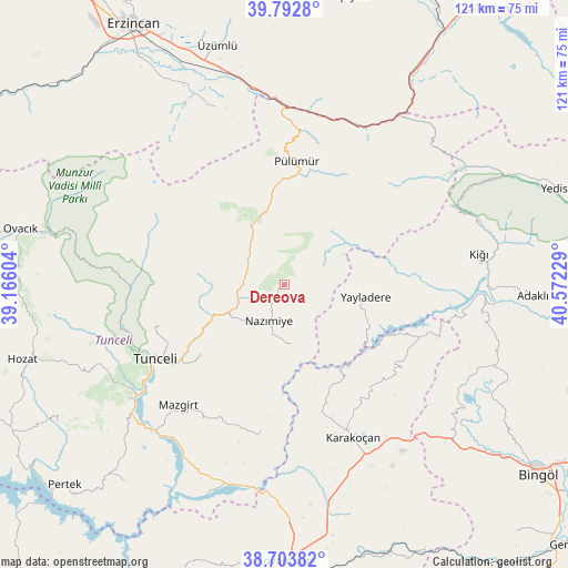
Dereova GPS coordinates[2]
39° 15' 1.512" North, 39° 52' 8.976" East
| Map corner | latitude | longitude |
|---|---|---|
| Upper-left | 39.7928°, | 39.16604° |
| Center: | 39.25042°, | 39.86916° |
| Lower-right: | 38.70382°, | 40.57229° |
| Map W x H: | 121.1×121.1 km | = 75.2×75.2mi |
| max Lat: | 42.02683° ⇑41.8% North |
| Dereova: | 39.25042° |
| min Lat: | ⇓58.2% South 35.9025° |
| min Long | Dereova | max Long |
| 25.90902° | 39.86916° | 44.60099° |
| W 73%⇐ | ⇒27% E |
Elevation
Elevation of Dereova is 1480 m = 4856 ft, and this is 762.6 m = 2502 ft above average elevation for this country.
| Max E: |
2682 m = 8799 ft | 9.9% |
| Dereova | 1480 m 4856 ft | |
| Avg. | 717.4 m = 2354 ft | |
Min E: |
0 m = 0 ft | 90.1% |
See also: Turkey elevation on elevation.city.
Geographical zone
Dereova is located in North temperate zone (between Tropic of Cancer and the Arctic Circle). Distance of this Northern Tropic circle is 1758.3 km =1092.6 mi to South.| Distance of | km | miles | from Dereova |
|---|---|---|---|
| North Pole | 5642.8 | 3506.3 | to North |
| Arctic Circle | 3036.9 | 1887 | to North |
| Tropic Cancer | 1758.3 | 1092.6 | to South |
| Equator | 4364.2 | 2711.8 | to South |


Nearby cities:
15 places around Dereova: (largest is in red/bold)
• Balpayam
24.8 km =15.4 mi,  40°
40°
• Dallıbahçe
13.1 km =8.1 mi,  176°
176°
• Darıkent
32.4 km =20.1 mi,  189°
189°
• Dağyolu
32.2 km =20 mi,  5°
5°
• Karakoçan
35.9 km =22.3 mi,  157°
157°
• Kocakoç
23.4 km =14.5 mi,  230°
230°
• Mazgirt
34.7 km =21.6 mi,  221°
221°
• Mezraa
15.5 km =9.6 mi,  345°
345°
• Nazimiye
8.6 km =5.3 mi,  204°
204°
• Pulumer
26.1 km =16.2 mi,  4°
4°
• Sütlüce
29.7 km =18.5 mi,  250°
250°
• Tunceli
32.7 km =20.3 mi,  239°
239°
• Turluk
21.1 km =13.1 mi, 1°
• Yayladere
17.5 km =10.9 mi,  98°
98°
• Çan
31 km =19.3 mi,  111°
111°
Sources, notices
• [Note1] Compared only with cities in Turkey existing in our database
• [Src1] Map data: © OpenStreetMap contributors (CC-BY-SA)
• [Src2] Other city data from geonames.org with taken over terms of usage.
• [Src3] Geographical zone / Annual Mean Temperature by Robert A. Rohde @ Wikipedia
