Tatvan geodata
Tatvan (Bitlis) is a seat of a second-order administrative division; located in Turkey in Europe/Istanbul (GMT+3) time zone. With population of 73,222 people, there are 125 cities with bigger population in this country. Compared to other cities in Turkey, 53% of cities are located further ↑North; 92.5% of cities are located further ←West and 95% of cities have lower elevation than Tatvan. Note1


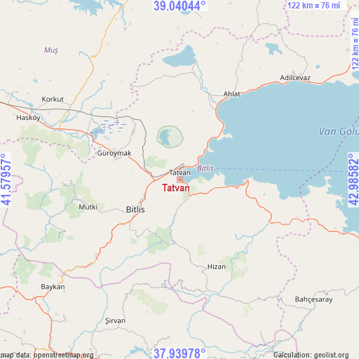
Tatvan GPS coordinates[2]
38° 29' 31.956" North, 42° 16' 57.684" East
| Map corner | latitude | longitude |
|---|---|---|
| Upper-left | 39.04044°, | 41.57957° |
| Center: | 38.49221°, | 42.28269° |
| Lower-right: | 37.93978°, | 42.98582° |
| Map W x H: | 122.4×122.4 km | = 76.1×76.1mi |
| max Lat: | 42.02683° ⇑53% North |
| Tatvan: | 38.49221° |
| min Lat: | ⇓47% South 35.9025° |
| min Long | Tatvan | max Long |
| 25.90902° | 42.28269° | 44.60099° |
| W 92.5%⇐ | ⇒7.5% E |
Elevation
Elevation of Tatvan is 1682 m = 5518 ft, and this is 964.6 m = 3165 ft above average elevation for this country.
| Max E: |
2682 m = 8799 ft | 5% |
| Tatvan | 1682 m 5518 ft | |
| Avg. | 717.4 m = 2354 ft | |
Min E: |
0 m = 0 ft | 95% |
See also: Tatvan elevation on elevation.city.
Geographical zone
Tatvan is located in North temperate zone (between Tropic of Cancer and the Arctic Circle). Distance of this Northern Tropic circle is 1674 km =1040.2 mi to South.| Distance of | km | miles | from Tatvan |
|---|---|---|---|
| North Pole | 5727.1 | 3558.7 | to North |
| Arctic Circle | 3121.2 | 1939.4 | to North |
| Tropic Cancer | 1674 | 1040.2 | to South |
| Equator | 4279.9 | 2659.4 | to South |


Nearby cities:
15 places around Tatvan: (largest is in red/bold)
• Ahlat
33.3 km =20.7 mi,  30°
30°
• Bitlis
18.3 km =11.4 mi,  236°
236°
• Cevizlik
35.6 km =22.1 mi,  187°
187°
• Geyikpınar
44.7 km =27.8 mi, 244°
• Güroymak
25 km =15.5 mi,  291°
291°
• Hizan
32 km =19.9 mi,  158°
158°
• Kavakbaşı
40.3 km =25 mi,  268°
268°
• Kotum
6.7 km =4.2 mi,  151°
151°
• Meydan
47.2 km =29.3 mi,  251°
251°
• Mutki
33 km =20.5 mi, 253°
• Narlıdere
45.2 km =28.1 mi,  229°
229°
• Ovakışla
36.3 km =22.6 mi,  4°
4°
• Reşadiye
22 km =13.7 mi,  90°
90°
• Sarıkonak
39.5 km =24.5 mi, 225°
• Simek
20.6 km =12.8 mi,  207°
207°
Sources, notices
• [Note1] Compared only with cities in Turkey existing in our database
• [Src1] Map data: © OpenStreetMap contributors (CC-BY-SA)
• [Src2] Other city data from geonames.org with taken over terms of usage.
• [Src3] Geographical zone / Annual Mean Temperature by Robert A. Rohde @ Wikipedia
