Ahlat geodata
Ahlat (Bitlis) is a seat of a second-order administrative division; located in Turkey in Europe/Istanbul (GMT+3) time zone. With population of 64,695 people, there are 142 cities with bigger population in this country. Compared to other cities in Turkey, 51.1% of cities are located further ↓South; 94.1% of cities are located further ←West and 95.6% of cities have lower elevation than Ahlat. Note1


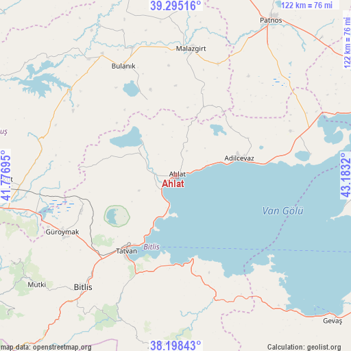
Ahlat GPS coordinates[2]
38° 44' 56.04" North, 42° 28' 48.252" East
| Map corner | latitude | longitude |
|---|---|---|
| Upper-left | 39.29516°, | 41.77695° |
| Center: | 38.7489°, | 42.48007° |
| Lower-right: | 38.19843°, | 43.1832° |
| Map W x H: | 121.9×121.9 km | = 75.7×75.7mi |
| max Lat: | 42.02683° ⇑48.9% North |
| Ahlat: | 38.7489° |
| min Lat: | ⇓51.1% South 35.9025° |
| min Long | Ahlat | max Long |
| 25.90902° | 42.48007° | 44.60099° |
| W 94.1%⇐ | ⇒5.9% E |
Elevation
Elevation of Ahlat is 1708 m = 5604 ft, and this is 990.6 m = 3250 ft above average elevation for this country.
| Max E: |
2682 m = 8799 ft | 4.4% |
| Ahlat | 1708 m 5604 ft | |
| Avg. | 717.4 m = 2354 ft | |
Min E: |
0 m = 0 ft | 95.6% |
See also: Ahlat elevation on elevation.city.
Geographical zone
Ahlat is located in North temperate zone (between Tropic of Cancer and the Arctic Circle). Distance of this Northern Tropic circle is 1702.6 km =1057.9 mi to South.| Distance of | km | miles | from Ahlat |
|---|---|---|---|
| North Pole | 5698.6 | 3540.9 | to North |
| Arctic Circle | 3092.7 | 1921.7 | to North |
| Tropic Cancer | 1702.6 | 1057.9 | to South |
| Equator | 4308.5 | 2677.2 | to South |


Nearby cities:
15 places around Ahlat: (largest is in red/bold)
• Adilcevaz
22.5 km =14 mi,  75°
75°
• Bitlis
50.4 km =31.3 mi,  219°
219°
• Bulanık
41.7 km =25.9 mi,  334°
334°
• Doğansu
47.9 km =29.8 mi,  27°
27°
• Erentepe
47.6 km =29.6 mi,  307°
307°
• Göldüzü
47.3 km =29.4 mi, 81°
• Güroymak
44.7 km =27.8 mi,  244°
244°
• Kotum
37.2 km =23.1 mi,  202°
202°
• Malazgirt
44.5 km =27.7 mi,  6°
6°
• Nurettin
53.6 km =33.3 mi,  354°
354°
• Ovakışla
16.1 km =10 mi,  298°
298°
• Reşadiye
29.3 km =18.2 mi,  170°
170°
• Sarısu
48.5 km =30.1 mi,  51°
51°
• Simek
53.9 km =33.5 mi,  209°
209°
• Tatvan
33.3 km =20.7 mi, 210°
Sources, notices
• [Note1] Compared only with cities in Turkey existing in our database
• [Src1] Map data: © OpenStreetMap contributors (CC-BY-SA)
• [Src2] Other city data from geonames.org with taken over terms of usage.
• [Src3] Geographical zone / Annual Mean Temperature by Robert A. Rohde @ Wikipedia
