Ovakışla geodata
Ovakışla (Bitlis) is a seat of a third-order administrative division; located in Turkey in Europe/Istanbul (GMT+3) time zone. In our database, there are 1323 cities with bigger population. Compared to other cities in Turkey, 52.2% of cities are located further ↓South; 92.8% of cities are located further ←West and 97.4% of cities have lower elevation than Ovakışla. Note1


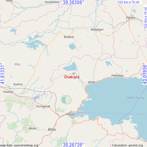
Ovakışla GPS coordinates[2]
38° 49' 2.388" North, 42° 18' 59.148" East
| Map corner | latitude | longitude |
|---|---|---|
| Upper-left | 39.36306°, | 41.61331° |
| Center: | 38.81733°, | 42.31643° |
| Lower-right: | 38.26739°, | 43.01956° |
| Map W x H: | 121.8×121.8 km | = 75.7×75.7mi |
| max Lat: | 42.02683° ⇑47.8% North |
| Ovakışla: | 38.81733° |
| min Lat: | ⇓52.2% South 35.9025° |
| min Long | Ovakışla | max Long |
| 25.90902° | 42.31643° | 44.60099° |
| W 92.8%⇐ | ⇒7.2% E |
Elevation
Elevation of Ovakışla is 1812 m = 5945 ft, and this is 1094.6 m = 3591 ft above average elevation for this country.
| Max E: |
2682 m = 8799 ft | 2.6% |
| Ovakışla | 1812 m 5945 ft | |
| Avg. | 717.4 m = 2354 ft | |
Min E: |
0 m = 0 ft | 97.4% |
See also: Turkey elevation on elevation.city.
Geographical zone
Ovakışla is located in North temperate zone (between Tropic of Cancer and the Arctic Circle). Distance of this Northern Tropic circle is 1710.2 km =1062.7 mi to South.| Distance of | km | miles | from Ovakışla |
|---|---|---|---|
| North Pole | 5691 | 3536.2 | to North |
| Arctic Circle | 3085.1 | 1917 | to North |
| Tropic Cancer | 1710.2 | 1062.7 | to South |
| Equator | 4316.1 | 2681.9 | to South |


Nearby cities:
15 places around Ovakışla: (largest is in red/bold)
• Adilcevaz
36 km =22.4 mi,  93°
93°
• Ahlat
16.1 km =10 mi,  118°
118°
• Bitlis
49.7 km =30.9 mi,  201°
201°
• Bulanık
30.2 km =18.8 mi,  352°
352°
• Doğansu
50.2 km =31.2 mi,  45°
45°
• Erentepe
31.8 km =19.8 mi,  312°
312°
• Güroymak
37.5 km =23.3 mi,  224°
224°
• Karaağıl
40.7 km =25.3 mi,  330°
330°
• Korkut
47.1 km =29.3 mi,  258°
258°
• Kotum
42.1 km =26.2 mi,  179°
179°
• Malazgirt
41.2 km =25.6 mi,  27°
27°
• Nurettin
46.6 km =29 mi,  10°
10°
• Nurettin
54.1 km =33.6 mi,  17°
17°
• Reşadiye
41.2 km =25.6 mi,  152°
152°
• Tatvan
36.3 km =22.6 mi, 184°
Sources, notices
• [Note1] Compared only with cities in Turkey existing in our database
• [Src1] Map data: © OpenStreetMap contributors (CC-BY-SA)
• [Src2] Other city data from geonames.org with taken over terms of usage.
• [Src3] Geographical zone / Annual Mean Temperature by Robert A. Rohde @ Wikipedia
