Güroymak geodata
Güroymak (Bitlis) is a seat of a second-order administrative division; located in Turkey in Europe/Istanbul (GMT+3) time zone. With population of 25,826 people, there are 278 cities with bigger population in this country. Compared to other cities in Turkey, 51.9% of cities are located further ↑North; 90.5% of cities are located further ←West and 84.8% of cities have lower elevation than Güroymak. Note1


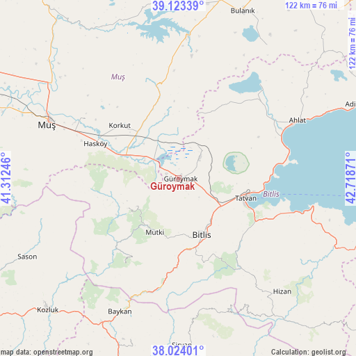
Güroymak GPS coordinates[2]
38° 34' 32.88" North, 42° 0' 56.088" East
| Map corner | latitude | longitude |
|---|---|---|
| Upper-left | 39.12339°, | 41.31246° |
| Center: | 38.5758°, | 42.01558° |
| Lower-right: | 38.02401°, | 42.71871° |
| Map W x H: | 122.2×122.2 km | = 75.9×75.9mi |
| max Lat: | 42.02683° ⇑51.9% North |
| Güroymak: | 38.5758° |
| min Lat: | ⇓48.1% South 35.9025° |
| min Long | Güroymak | max Long |
| 25.90902° | 42.01558° | 44.60099° |
| W 90.5%⇐ | ⇒9.5% E |
Elevation
Elevation of Güroymak is 1304 m = 4278 ft, and this is 586.6 m = 1925 ft above average elevation for this country.
| Max E: |
2682 m = 8799 ft | 15.2% |
| Güroymak | 1304 m 4278 ft | |
| Avg. | 717.4 m = 2354 ft | |
Min E: |
0 m = 0 ft | 84.8% |
See also: Turkey elevation on elevation.city.
Geographical zone
Güroymak is located in North temperate zone (between Tropic of Cancer and the Arctic Circle). Distance of this Northern Tropic circle is 1683.3 km =1046 mi to South.| Distance of | km | miles | from Güroymak |
|---|---|---|---|
| North Pole | 5717.8 | 3552.9 | to North |
| Arctic Circle | 3111.9 | 1933.6 | to North |
| Tropic Cancer | 1683.3 | 1046 | to South |
| Equator | 4289.2 | 2665.2 | to South |


Nearby cities:
15 places around Güroymak: (largest is in red/bold)
• Ahlat
44.7 km =27.8 mi,  64°
64°
• Bitlis
21 km =13 mi,  157°
157°
• Geyikpınar
33.4 km =20.8 mi,  210°
210°
• Hasköy
31.6 km =19.6 mi,  292°
292°
• Kavakbaşı
19.9 km =12.4 mi,  238°
238°
• Korkut
26.7 km =16.6 mi,  311°
311°
• Kotum
30.5 km =19 mi,  119°
119°
• Meydan
32.5 km =20.2 mi,  221°
221°
• Mutki
20.6 km =12.8 mi,  203°
203°
• Narlıdere
40.3 km =25 mi, 195°
• Ovakışla
37.5 km =23.3 mi,  44°
44°
• Reşadiye
46.2 km =28.7 mi,  102°
102°
• Sarıkonak
37.3 km =23.2 mi,  187°
187°
• Simek
30.9 km =19.2 mi,  153°
153°
• Tatvan
25 km =15.5 mi,  111°
111°
Sources, notices
• [Note1] Compared only with cities in Turkey existing in our database
• [Src1] Map data: © OpenStreetMap contributors (CC-BY-SA)
• [Src2] Other city data from geonames.org with taken over terms of usage.
• [Src3] Geographical zone / Annual Mean Temperature by Robert A. Rohde @ Wikipedia
