Geyikpınar geodata
Geyikpınar (Bitlis) is a seat of a third-order administrative division; located in Turkey in Europe/Istanbul (GMT+3) time zone. In our database, there are 1323 cities with bigger population. Compared to other cities in Turkey, 56% of cities are located further ↑North; 88.7% of cities are located further ←West and 95.7% of cities have lower elevation than Geyikpınar. Note1


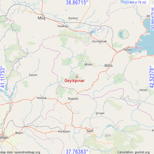
Geyikpınar GPS coordinates[2]
38° 19' 3.324" North, 41° 49' 14.34" East
| Map corner | latitude | longitude |
|---|---|---|
| Upper-left | 38.86715°, | 41.11753° |
| Center: | 38.31759°, | 41.82065° |
| Lower-right: | 37.76383°, | 42.52378° |
| Map W x H: | 122.7×122.7 km | = 76.2×76.2mi |
| max Lat: | 42.02683° ⇑56% North |
| Geyikpınar: | 38.31759° |
| min Lat: | ⇓44% South 35.9025° |
| min Long | Geyikpınar | max Long |
| 25.90902° | 41.82065° | 44.60099° |
| W 88.7%⇐ | ⇒11.3% E |
Elevation
Elevation of Geyikpınar is 1710 m = 5610 ft, and this is 992.6 m = 3257 ft above average elevation for this country.
| Max E: |
2682 m = 8799 ft | 4.3% |
| Geyikpınar | 1710 m 5610 ft | |
| Avg. | 717.4 m = 2354 ft | |
Min E: |
0 m = 0 ft | 95.7% |
See also: Turkey elevation on elevation.city.
Geographical zone
Geyikpınar is located in North temperate zone (between Tropic of Cancer and the Arctic Circle). Distance of this Northern Tropic circle is 1654.6 km =1028.1 mi to South.| Distance of | km | miles | from Geyikpınar |
|---|---|---|---|
| North Pole | 5746.5 | 3570.7 | to North |
| Arctic Circle | 3140.7 | 1951.5 | to North |
| Tropic Cancer | 1654.6 | 1028.1 | to South |
| Equator | 4260.5 | 2647.4 | to South |


Nearby cities:
15 places around Geyikpınar: (largest is in red/bold)
• Baykan
18.3 km =11.4 mi,  193°
193°
• Bitlis
26.7 km =16.6 mi,  69°
69°
• Dilektepe
27 km =16.8 mi,  178°
178°
• Doluharman
37.9 km =23.5 mi,  167°
167°
• Güroymak
33.4 km =20.8 mi,  30°
30°
• Kavakbaşı
18.4 km =11.4 mi,  359°
359°
• Kozluk
33.1 km =20.6 mi,  244°
244°
• Melefan
26.8 km =16.7 mi, 235°
• Meydan
6.2 km =3.9 mi,  313°
313°
• Mutki
13.1 km =8.1 mi,  41°
41°
• Narlıdere
11.8 km =7.3 mi,  148°
148°
• Sarıkonak
14.7 km =9.1 mi,  124°
124°
• Sason
35.5 km =22.1 mi,  271°
271°
• Simek
30.9 km =19.2 mi,  87°
87°
• Şirvan
33.5 km =20.8 mi, 147°
Sources, notices
• [Note1] Compared only with cities in Turkey existing in our database
• [Src1] Map data: © OpenStreetMap contributors (CC-BY-SA)
• [Src2] Other city data from geonames.org with taken over terms of usage.
• [Src3] Geographical zone / Annual Mean Temperature by Robert A. Rohde @ Wikipedia
