Kızılağaç geodata
Kızılağaç (Antalya) is a populated place; located in Turkey in Europe/Istanbul (GMT+3) time zone. With population of 1,440 people, there are 1016 cities with bigger population in this country. Compared to other cities in Turkey, 94.7% of cities are located further ↑North; 68.7% of cities are located further →East and 94.3% of cities have higher elevation than Kızılağaç. Note1


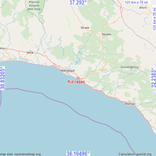
Kızılağaç GPS coordinates[2]
36° 43' 49.98" North, 31° 32' 6.612" East
| Map corner | latitude | longitude |
|---|---|---|
| Upper-left | 37.292°, | 30.83205° |
| Center: | 36.73055°, | 31.53517° |
| Lower-right: | 36.16496°, | 32.2383° |
| Map W x H: | 125.3×125.3 km | = 77.9×77.9mi |
| max Lat: | 42.02683° ⇑94.7% North |
| Kızılağaç: | 36.73055° |
| min Lat: | ⇓5.3% South 35.9025° |
| min Long | Kızılağaç | max Long |
| 25.90902° | 31.53517° | 44.60099° |
| W 31.3%⇐ | ⇒68.7% E |
Elevation
Elevation of Kızılağaç is 18 m = 59 ft, and this is 699.4 m = 2295 ft below average elevation for this country.
| Max E: |
2682 m = 8799 ft | 94.3% |
| Avg. | 717.4 m = 2354 ft | |
| Kızılağaç | 18 m = 59 ft | |
Min E: |
0 m = 0 ft | 5.7% |
See also: Turkey elevation on elevation.city.
Geographical zone
Kızılağaç is located in North temperate zone (between Tropic of Cancer and the Arctic Circle). Distance of this Northern Tropic circle is 1478.1 km =918.4 mi to South.| Distance of | km | miles | from Kızılağaç |
|---|---|---|---|
| North Pole | 5923 | 3680.4 | to North |
| Arctic Circle | 3317.1 | 2061.1 | to North |
| Tropic Cancer | 1478.1 | 918.4 | to South |
| Equator | 4084.1 | 2537.7 | to South |


Nearby cities:
15 places around Kızılağaç: (largest is in red/bold)
• Akseki
42 km =26.1 mi,  32°
32°
• Avsallar
24 km =14.9 mi,  119°
119°
• Boğazkent
35.8 km =22.2 mi,  292°
292°
• Büyükbelkis
40.5 km =25.2 mi,  305°
305°
• Evrenseki
20 km =12.4 mi, 306°
• Geriş
31.2 km =19.4 mi, 34°
• Güzelbağ
32.4 km =20.1 mi,  89°
89°
• Güzelsu
33.9 km =21.1 mi,  57°
57°
• Manavgat
10.3 km =6.4 mi, 307°
• Okurcalar
17.6 km =10.9 mi, 121°
• Payallar
31.6 km =19.6 mi, 117°
• Side
13.6 km =8.5 mi, 287°
• Taşağıl
34.1 km =21.2 mi, 308°
• Türkler
29.2 km =18.1 mi, 119°
• İbradı
41.1 km =25.5 mi,  7°
7°
Sources, notices
• [Note1] Compared only with cities in Turkey existing in our database
• [Src1] Map data: © OpenStreetMap contributors (CC-BY-SA)
• [Src2] Other city data from geonames.org with taken over terms of usage.
• [Src3] Geographical zone / Annual Mean Temperature by Robert A. Rohde @ Wikipedia
