Avine geodata
Avine (Mardin) is a seat of a third-order administrative division; located in Turkey in Europe/Istanbul (GMT+3) time zone. With population of 4,139 people, there are 769 cities with bigger population in this country. Compared to other cities in Turkey, 72.9% of cities are located further ↑North; 78.7% of cities are located further ←West and 58.5% of cities have lower elevation than Avine. Note1


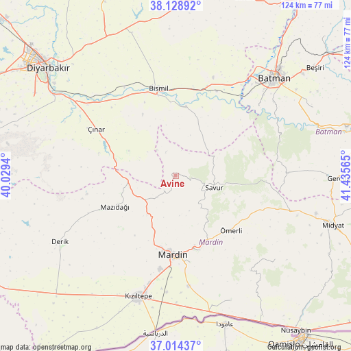
Avine GPS coordinates[2]
37° 34' 25.428" North, 40° 43' 57.072" East
| Map corner | latitude | longitude |
|---|---|---|
| Upper-left | 38.12892°, | 40.0294° |
| Center: | 37.57373°, | 40.73252° |
| Lower-right: | 37.01437°, | 41.43565° |
| Map W x H: | 123.9×123.9 km | = 77×77mi |
| max Lat: | 42.02683° ⇑72.9% North |
| Avine: | 37.57373° |
| min Lat: | ⇓27.1% South 35.9025° |
| min Long | Avine | max Long |
| 25.90902° | 40.73252° | 44.60099° |
| W 78.7%⇐ | ⇒21.3% E |
Elevation
Elevation of Avine is 854 m = 2802 ft, and this is 136.6 m = 448 ft above average elevation for this country.
| Max E: |
2682 m = 8799 ft | 41.5% |
| Avine | 854 m 2802 ft | |
| Avg. | 717.4 m = 2354 ft | |
Min E: |
0 m = 0 ft | 58.5% |
See also: Turkey elevation on elevation.city.
Geographical zone
Avine is located in North temperate zone (between Tropic of Cancer and the Arctic Circle). Distance of this Northern Tropic circle is 1571.9 km =976.7 mi to South.| Distance of | km | miles | from Avine |
|---|---|---|---|
| North Pole | 5829.3 | 3622.2 | to North |
| Arctic Circle | 3223.4 | 2002.9 | to North |
| Tropic Cancer | 1571.9 | 976.7 | to South |
| Equator | 4177.8 | 2596 | to South |


Nearby cities:
15 places around Avine: (largest is in red/bold)
• Aran
14.1 km =8.8 mi,  174°
174°
• Bağlıca
6.6 km =4.1 mi,  218°
218°
• Başkavak
13.7 km =8.5 mi,  94°
94°
• Cillin
4.9 km =3 mi,  299°
299°
• Doruk
15.3 km =9.5 mi,  20°
20°
• Harmanlı
19.2 km =11.9 mi,  26°
26°
• Kavsan
11.3 km =7 mi,  324°
324°
• Kayatepe
18.2 km =11.3 mi,  109°
109°
• Pınardere
14.4 km =8.9 mi,  141°
141°
• Savur
13.6 km =8.5 mi, 108°
• Soylu
11.3 km =7 mi,  40°
40°
• Yaprakbaşı
18.7 km =11.6 mi, 298°
• Yaylacık
15.7 km =9.8 mi,  195°
195°
• Yeşilalan
13.4 km =8.3 mi,  159°
159°
• Şenocak
9.2 km =5.7 mi,  338°
338°
Sources, notices
• [Note1] Compared only with cities in Turkey existing in our database
• [Src1] Map data: © OpenStreetMap contributors (CC-BY-SA)
• [Src2] Other city data from geonames.org with taken over terms of usage.
• [Src3] Geographical zone / Annual Mean Temperature by Robert A. Rohde @ Wikipedia
