Savur geodata
Savur (Mardin) is a seat of a second-order administrative division; located in Turkey in Europe/Istanbul (GMT+3) time zone. With population of 8,658 people, there are 546 cities with bigger population in this country. Compared to other cities in Turkey, 73.9% of cities are located further ↑North; 80.1% of cities are located further ←West and 65.1% of cities have lower elevation than Savur. Note1


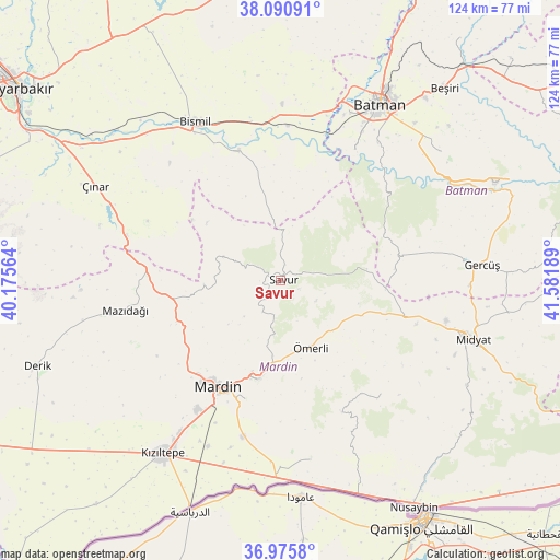
Savur GPS coordinates[2]
37° 32' 7.584" North, 40° 52' 43.536" East
| Map corner | latitude | longitude |
|---|---|---|
| Upper-left | 38.09091°, | 40.17564° |
| Center: | 37.53544°, | 40.87876° |
| Lower-right: | 36.9758°, | 41.58189° |
| Map W x H: | 124×124 km | = 77.1×77.1mi |
| max Lat: | 42.02683° ⇑73.9% North |
| Savur: | 37.53544° |
| min Lat: | ⇓26.1% South 35.9025° |
| min Long | Savur | max Long |
| 25.90902° | 40.87876° | 44.60099° |
| W 80.1%⇐ | ⇒19.9% E |
Elevation
Elevation of Savur is 961 m = 3153 ft, and this is 243.6 m = 799 ft above average elevation for this country.
| Max E: |
2682 m = 8799 ft | 34.9% |
| Savur | 961 m 3153 ft | |
| Avg. | 717.4 m = 2354 ft | |
Min E: |
0 m = 0 ft | 65.1% |
See also: Turkey elevation on elevation.city.
Geographical zone
Savur is located in North temperate zone (between Tropic of Cancer and the Arctic Circle). Distance of this Northern Tropic circle is 1567.6 km =974.1 mi to South.| Distance of | km | miles | from Savur |
|---|---|---|---|
| North Pole | 5833.5 | 3624.8 | to North |
| Arctic Circle | 3227.6 | 2005.5 | to North |
| Tropic Cancer | 1567.6 | 974.1 | to South |
| Equator | 4173.5 | 2593.3 | to South |


Nearby cities:
15 places around Savur: (largest is in red/bold)
• Aran
15.1 km =9.4 mi,  229°
229°
• Avine
13.6 km =8.5 mi,  288°
288°
• Bağlıca
17 km =10.6 mi,  266°
266°
• Başkavak
3.3 km =2.1 mi,  13°
13°
• Dereyanı
12.1 km =7.5 mi,  187°
187°
• Evkuran
15.7 km =9.8 mi,  28°
28°
• Kayatepe
4.6 km =2.9 mi,  112°
112°
• Pınardere
8.1 km =5 mi,  209°
209°
• Reshidi
9.1 km =5.7 mi,  119°
119°
• Soylu
13.9 km =8.6 mi,  336°
336°
• Tokluca
14.9 km =9.3 mi,  68°
68°
• Yenilmez
10.2 km =6.3 mi, 106°
• Yeşilalan
11.8 km =7.3 mi, 225°
• Çınaraltı
16.8 km =10.4 mi, 185°
• Ömerli
16.6 km =10.3 mi,  156°
156°
Sources, notices
• [Note1] Compared only with cities in Turkey existing in our database
• [Src1] Map data: © OpenStreetMap contributors (CC-BY-SA)
• [Src2] Other city data from geonames.org with taken over terms of usage.
• [Src3] Geographical zone / Annual Mean Temperature by Robert A. Rohde @ Wikipedia
