Sivrice geodata
Sivrice (Elazığ) is a seat of a second-order administrative division; located in Turkey in Europe/Istanbul (GMT+3) time zone. With population of 5,481 people, there are 687 cities with bigger population in this country. Compared to other cities in Turkey, 53.7% of cities are located further ↑North; 69.9% of cities are located further ←West and 84.6% of cities have lower elevation than Sivrice. Note1


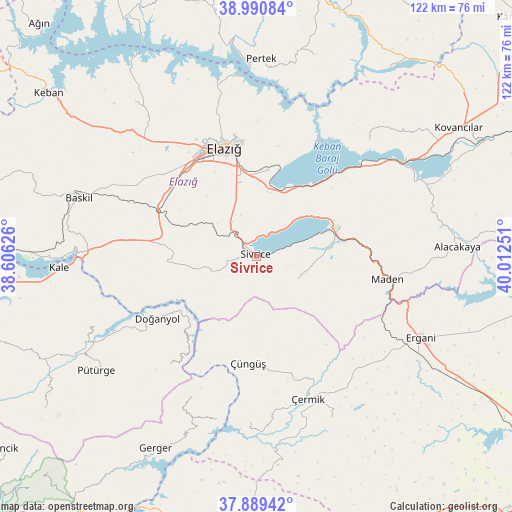
Sivrice GPS coordinates[2]
38° 26' 32.028" North, 39° 18' 33.768" East
| Map corner | latitude | longitude |
|---|---|---|
| Upper-left | 38.99084°, | 38.60626° |
| Center: | 38.44223°, | 39.30938° |
| Lower-right: | 37.88942°, | 40.01251° |
| Map W x H: | 122.5×122.5 km | = 76.1×76.1mi |
| max Lat: | 42.02683° ⇑53.7% North |
| Sivrice: | 38.44223° |
| min Lat: | ⇓46.3% South 35.9025° |
| min Long | Sivrice | max Long |
| 25.90902° | 39.30938° | 44.60099° |
| W 69.9%⇐ | ⇒30.1% E |
Elevation
Elevation of Sivrice is 1298 m = 4259 ft, and this is 580.6 m = 1905 ft above average elevation for this country.
| Max E: |
2682 m = 8799 ft | 15.4% |
| Sivrice | 1298 m 4259 ft | |
| Avg. | 717.4 m = 2354 ft | |
Min E: |
0 m = 0 ft | 84.6% |
See also: Turkey elevation on elevation.city.
Geographical zone
Sivrice is located in North temperate zone (between Tropic of Cancer and the Arctic Circle). Distance of this Northern Tropic circle is 1668.5 km =1036.8 mi to South.| Distance of | km | miles | from Sivrice |
|---|---|---|---|
| North Pole | 5732.7 | 3562.1 | to North |
| Arctic Circle | 3126.8 | 1942.9 | to North |
| Tropic Cancer | 1668.5 | 1036.8 | to South |
| Equator | 4274.4 | 2656 | to South |


Nearby cities:
15 places around Sivrice: (largest is in red/bold)
• Doğanyol
28.3 km =17.6 mi,  237°
237°
• Elazığ
26.9 km =16.7 mi,  343°
343°
• Gözeli
22 km =13.7 mi,  264°
264°
• Hankendi
26.1 km =16.2 mi,  302°
302°
• Harput
29.7 km =18.5 mi,  348°
348°
• Hazar
11.7 km =7.3 mi,  121°
121°
• Maden
31.5 km =19.6 mi,  101°
101°
• Mollakendi
15.2 km =9.4 mi,  7°
7°
• Poyraz
36.8 km =22.9 mi,  317°
317°
• Taraksu
35 km =21.7 mi,  203°
203°
• Yoğun
42.1 km =26.2 mi,  154°
154°
• Çaybağı
38.9 km =24.2 mi,  43°
43°
• Çermik
36.1 km =22.4 mi,  160°
160°
• Çüngüş
26.1 km =16.2 mi,  184°
184°
• İçme
28.3 km =17.6 mi,  48°
48°
Sources, notices
• [Note1] Compared only with cities in Turkey existing in our database
• [Src1] Map data: © OpenStreetMap contributors (CC-BY-SA)
• [Src2] Other city data from geonames.org with taken over terms of usage.
• [Src3] Geographical zone / Annual Mean Temperature by Robert A. Rohde @ Wikipedia
