Poyraz geodata
Poyraz (Elazığ) is a seat of a third-order administrative division; located in Turkey in Europe/Istanbul (GMT+3) time zone. In our database, there are 1323 cities with bigger population. Compared to other cities in Turkey, 50.1% of cities are located further ↑North; 67.8% of cities are located further ←West and 73.4% of cities have lower elevation than Poyraz. Note1


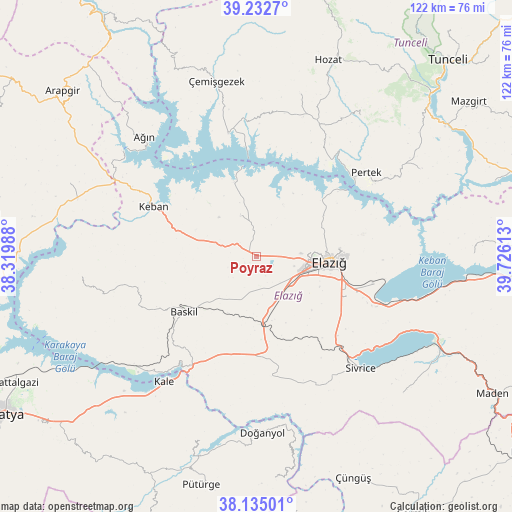
Poyraz GPS coordinates[2]
38° 41' 9.456" North, 39° 1' 22.8" East
| Map corner | latitude | longitude |
|---|---|---|
| Upper-left | 39.2327°, | 38.31988° |
| Center: | 38.68596°, | 39.023° |
| Lower-right: | 38.13501°, | 39.72613° |
| Map W x H: | 122.1×122.1 km | = 75.9×75.9mi |
| max Lat: | 42.02683° ⇑50.1% North |
| Poyraz: | 38.68596° |
| min Lat: | ⇓49.9% South 35.9025° |
| min Long | Poyraz | max Long |
| 25.90902° | 39.023° | 44.60099° |
| W 67.8%⇐ | ⇒32.2% E |
Elevation
Elevation of Poyraz is 1079 m = 3540 ft, and this is 361.6 m = 1186 ft above average elevation for this country.
| Max E: |
2682 m = 8799 ft | 26.6% |
| Poyraz | 1079 m 3540 ft | |
| Avg. | 717.4 m = 2354 ft | |
Min E: |
0 m = 0 ft | 73.4% |
See also: Turkey elevation on elevation.city.
Geographical zone
Poyraz is located in North temperate zone (between Tropic of Cancer and the Arctic Circle). Distance of this Northern Tropic circle is 1695.6 km =1053.6 mi to South.| Distance of | km | miles | from Poyraz |
|---|---|---|---|
| North Pole | 5705.6 | 3545.3 | to North |
| Arctic Circle | 3099.7 | 1926.1 | to North |
| Tropic Cancer | 1695.6 | 1053.6 | to South |
| Equator | 4301.5 | 2672.8 | to South |


Nearby cities:
15 places around Poyraz: (largest is in red/bold)
• Akçapınar
29.9 km =18.6 mi,  346°
346°
• Ağın
38.9 km =24.2 mi,  316°
316°
• Baskil
22.2 km =13.8 mi,  233°
233°
• Elazığ
17.4 km =10.8 mi,  94°
94°
• Gözeli
29.2 km =18.1 mi,  174°
174°
• Hankendi
13.4 km =8.3 mi, 167°
• Harput
19.1 km =11.9 mi,  84°
84°
• Hıdırbaba
9.9 km =6.2 mi,  336°
336°
• Kale
37.2 km =23.1 mi,  216°
216°
• Keban
27.7 km =17.2 mi,  295°
295°
• Kuşsarayı
39.7 km =24.7 mi, 228°
• Mollakendi
29.5 km =18.3 mi,  114°
114°
• Pertek
32.8 km =20.4 mi,  52°
52°
• Sivrice
36.8 km =22.9 mi,  137°
137°
• Çağlarca
40.3 km =25 mi,  14°
14°
Sources, notices
• [Note1] Compared only with cities in Turkey existing in our database
• [Src1] Map data: © OpenStreetMap contributors (CC-BY-SA)
• [Src2] Other city data from geonames.org with taken over terms of usage.
• [Src3] Geographical zone / Annual Mean Temperature by Robert A. Rohde @ Wikipedia
