Taraksu geodata
Taraksu (Adıyaman) is a seat of a third-order administrative division; located in Turkey in Europe/Istanbul (GMT+3) time zone. In our database, there are 1323 cities with bigger population. Compared to other cities in Turkey, 58.8% of cities are located further ↑North; 69% of cities are located further ←West and 60.3% of cities have lower elevation than Taraksu. Note1


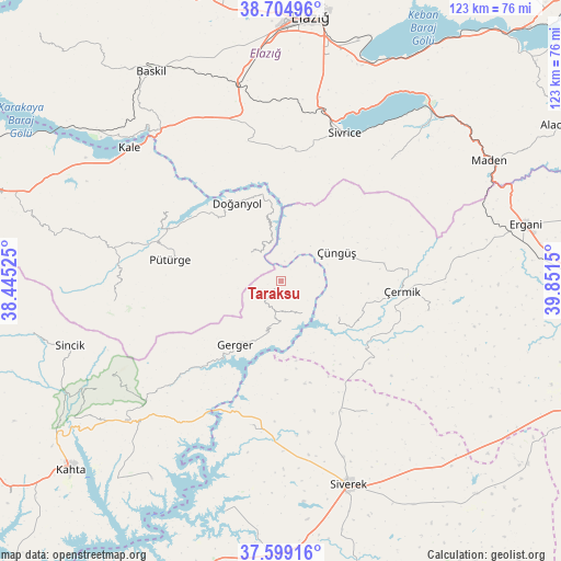
Taraksu GPS coordinates[2]
38° 9' 14.976" North, 39° 8' 54.132" East
| Map corner | latitude | longitude |
|---|---|---|
| Upper-left | 38.70496°, | 38.44525° |
| Center: | 38.15416°, | 39.14837° |
| Lower-right: | 37.59916°, | 39.8515° |
| Map W x H: | 123×123 km | = 76.4×76.4mi |
| max Lat: | 42.02683° ⇑58.8% North |
| Taraksu: | 38.15416° |
| min Lat: | ⇓41.2% South 35.9025° |
| min Long | Taraksu | max Long |
| 25.90902° | 39.14837° | 44.60099° |
| W 69%⇐ | ⇒31% E |
Elevation
Elevation of Taraksu is 888 m = 2913 ft, and this is 170.6 m = 560 ft above average elevation for this country.
| Max E: |
2682 m = 8799 ft | 39.7% |
| Taraksu | 888 m 2913 ft | |
| Avg. | 717.4 m = 2354 ft | |
Min E: |
0 m = 0 ft | 60.3% |
See also: Turkey elevation on elevation.city.
Geographical zone
Taraksu is located in North temperate zone (between Tropic of Cancer and the Arctic Circle). Distance of this Northern Tropic circle is 1636.4 km =1016.8 mi to South.| Distance of | km | miles | from Taraksu |
|---|---|---|---|
| North Pole | 5764.7 | 3582 | to North |
| Arctic Circle | 3158.8 | 1962.8 | to North |
| Tropic Cancer | 1636.4 | 1016.8 | to South |
| Equator | 4242.3 | 2636 | to South |


Nearby cities:
15 places around Taraksu: (largest is in red/bold)
• Bucak
32.6 km =20.3 mi,  193°
193°
• Doğanyol
19.7 km =12.2 mi,  329°
329°
• Gerger
17.2 km =10.7 mi,  215°
215°
• Gerger
25.5 km =15.8 mi,  206°
206°
• Gözeli
31.1 km =19.3 mi,  345°
345°
• Hazar
35.4 km =22 mi,  42°
42°
• Kale
43.9 km =27.3 mi,  311°
311°
• Karahan
32.8 km =20.4 mi,  150°
150°
• Pütürge
25.4 km =15.8 mi,  281°
281°
• Sivrice
35 km =21.7 mi,  23°
23°
• Taraksu
16.3 km =10.1 mi,  200°
200°
• Tepehan
37.1 km =23.1 mi,  263°
263°
• Yoğun
32.5 km =20.2 mi,  100°
100°
• Çermik
26 km =16.2 mi,  94°
94°
• Çüngüş
13.4 km =8.3 mi,  63°
63°
Sources, notices
• [Note1] Compared only with cities in Turkey existing in our database
• [Src1] Map data: © OpenStreetMap contributors (CC-BY-SA)
• [Src2] Other city data from geonames.org with taken over terms of usage.
• [Src3] Geographical zone / Annual Mean Temperature by Robert A. Rohde @ Wikipedia
