Sincan geodata
Sincan (Sivas) is a seat of a third-order administrative division; located in Turkey in Europe/Istanbul (GMT+3) time zone. In our database, there are 1323 cities with bigger population. Compared to other cities in Turkey, 60.9% of cities are located further ↓South; 61% of cities are located further ←West and 81.6% of cities have lower elevation than Sincan. Note1


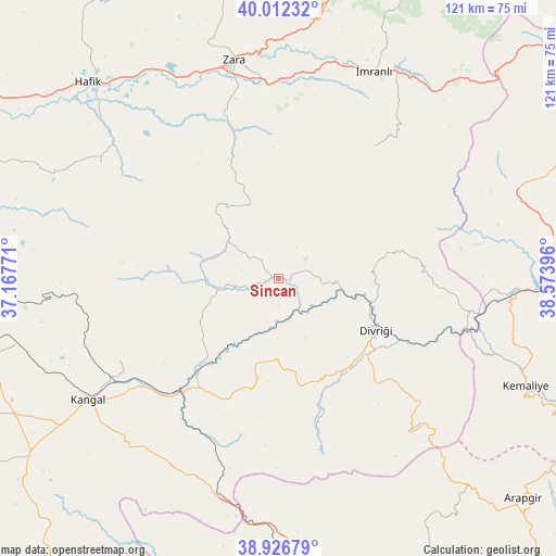
Sincan GPS coordinates[2]
39° 28' 18.012" North, 37° 52' 14.988" East
| Map corner | latitude | longitude |
|---|---|---|
| Upper-left | 40.01232°, | 37.16771° |
| Center: | 39.47167°, | 37.87083° |
| Lower-right: | 38.92679°, | 38.57396° |
| Map W x H: | 120.7×120.7 km | = 75×75mi |
| max Lat: | 42.02683° ⇑39.1% North |
| Sincan: | 39.47167° |
| min Lat: | ⇓60.9% South 35.9025° |
| min Long | Sincan | max Long |
| 25.90902° | 37.87083° | 44.60099° |
| W 61%⇐ | ⇒39% E |
Elevation
Elevation of Sincan is 1225 m = 4019 ft, and this is 507.6 m = 1665 ft above average elevation for this country.
| Max E: |
2682 m = 8799 ft | 18.4% |
| Sincan | 1225 m 4019 ft | |
| Avg. | 717.4 m = 2354 ft | |
Min E: |
0 m = 0 ft | 81.6% |
See also: Turkey elevation on elevation.city.
Geographical zone
Sincan is located in North temperate zone (between Tropic of Cancer and the Arctic Circle). Distance of this Northern Tropic circle is 1782.9 km =1107.8 mi to South.| Distance of | km | miles | from Sincan |
|---|---|---|---|
| North Pole | 5618.2 | 3491 | to North |
| Arctic Circle | 3012.3 | 1871.8 | to North |
| Tropic Cancer | 1782.9 | 1107.8 | to South |
| Equator | 4388.8 | 2727.1 | to South |


Nearby cities:
15 places around Sincan: (largest is in red/bold)
• Alacahan
47.9 km =29.8 mi,  212°
212°
• Armutlu
49.1 km =30.5 mi,  76°
76°
• Beypınarı
14.6 km =9.1 mi,  285°
285°
• Bulucan
27.4 km =17 mi,  339°
339°
• Celâlli
45.5 km =28.3 mi,  302°
302°
• Danişment
43.7 km =27.2 mi,  139°
139°
• Divriği
23.7 km =14.7 mi,  118°
118°
• Gedikbaşı
32.4 km =20.1 mi,  86°
86°
• Kangal
49 km =30.4 mi,  237°
237°
• Karacaören
35.6 km =22.1 mi,  36°
36°
• Kavak
39 km =24.2 mi, 239°
• Mursal
34.6 km =21.5 mi,  167°
167°
• Zara
48.3 km =30 mi,  348°
348°
• Çetinkaya
31.4 km =19.5 mi,  222°
222°
• İmranlı
49.5 km =30.8 mi,  24°
24°
Sources, notices
• [Note1] Compared only with cities in Turkey existing in our database
• [Src1] Map data: © OpenStreetMap contributors (CC-BY-SA)
• [Src2] Other city data from geonames.org with taken over terms of usage.
• [Src3] Geographical zone / Annual Mean Temperature by Robert A. Rohde @ Wikipedia
