Zara geodata
Zara (Sivas) is a seat of a second-order administrative division; located in Turkey in Europe/Istanbul (GMT+3) time zone. With population of 12,797 people, there are 435 cities with bigger population in this country. Compared to other cities in Turkey, 67.2% of cities are located further ↓South; 60.2% of cities are located further ←West and 86.1% of cities have lower elevation than Zara. Note1


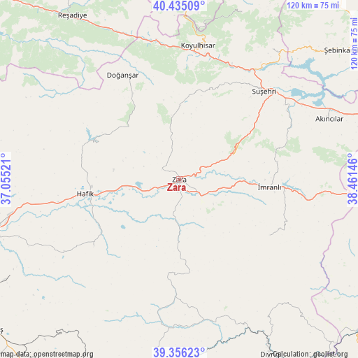
Zara GPS coordinates[2]
39° 53' 52.008" North, 37° 45' 29.988" East
| Map corner | latitude | longitude |
|---|---|---|
| Upper-left | 40.43509°, | 37.05521° |
| Center: | 39.89778°, | 37.75833° |
| Lower-right: | 39.35623°, | 38.46146° |
| Map W x H: | 120×120 km | = 74.6×74.6mi |
| max Lat: | 42.02683° ⇑32.8% North |
| Zara: | 39.89778° |
| min Lat: | ⇓67.2% South 35.9025° |
| min Long | Zara | max Long |
| 25.90902° | 37.75833° | 44.60099° |
| W 60.2%⇐ | ⇒39.8% E |
Elevation
Elevation of Zara is 1342 m = 4403 ft, and this is 624.6 m = 2049 ft above average elevation for this country.
| Max E: |
2682 m = 8799 ft | 13.9% |
| Zara | 1342 m 4403 ft | |
| Avg. | 717.4 m = 2354 ft | |
Min E: |
0 m = 0 ft | 86.1% |
See also: Turkey elevation on elevation.city.
Geographical zone
Zara is located in North temperate zone (between Tropic of Cancer and the Arctic Circle). Distance of this Northern Tropic circle is 1830.3 km =1137.3 mi to South.| Distance of | km | miles | from Zara |
|---|---|---|---|
| North Pole | 5570.8 | 3461.5 | to North |
| Arctic Circle | 2965 | 1842.4 | to North |
| Tropic Cancer | 1830.3 | 1137.3 | to South |
| Equator | 4436.2 | 2756.5 | to South |


Nearby cities:
15 places around Zara: (largest is in red/bold)
• Aksu
31.8 km =19.8 mi,  47°
47°
• Akıncılar
53.5 km =33.2 mi,  68°
68°
• Beypınarı
43.7 km =27.2 mi,  185°
185°
• Bulucan
21.7 km =13.5 mi,  179°
179°
• Celâlli
36.6 km =22.7 mi,  231°
231°
• Doğanşar
39.6 km =24.6 mi,  330°
330°
• Gökçekent
52.9 km =32.9 mi,  35°
35°
• Hafik
32.1 km =19.9 mi,  261°
261°
• Karacaören
35.7 km =22.2 mi,  121°
121°
• Karayün
45.5 km =28.3 mi,  238°
238°
• Koyulhisar
45.3 km =28.1 mi,  7°
7°
• Sincan
48.3 km =30 mi,  168°
168°
• Suşehri
40.2 km =25 mi, 43°
• İmranlı
30.4 km =18.9 mi,  94°
94°
• Şerefiye
23.8 km =14.8 mi,  359°
359°
Sources, notices
• [Note1] Compared only with cities in Turkey existing in our database
• [Src1] Map data: © OpenStreetMap contributors (CC-BY-SA)
• [Src2] Other city data from geonames.org with taken over terms of usage.
• [Src3] Geographical zone / Annual Mean Temperature by Robert A. Rohde @ Wikipedia
