İmranlı geodata
İmranlı (Sivas) is a seat of a second-order administrative division; located in Turkey in Europe/Istanbul (GMT+3) time zone. With population of 7,192 people, there are 610 cities with bigger population in this country. Compared to other cities in Turkey, 67% of cities are located further ↓South; 62.3% of cities are located further ←West and 93.6% of cities have lower elevation than İmranlı. Note1


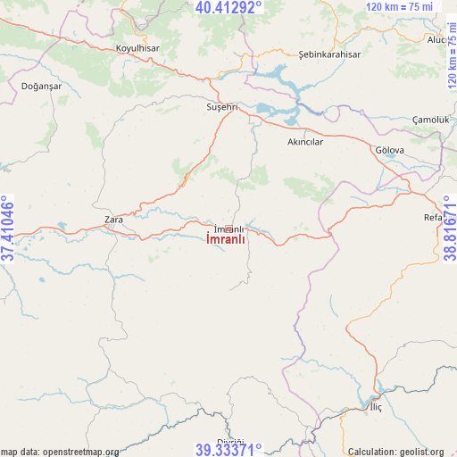
İmranlı GPS coordinates[2]
39° 52' 31.584" North, 38° 6' 48.888" East
| Map corner | latitude | longitude |
|---|---|---|
| Upper-left | 40.41292°, | 37.41046° |
| Center: | 39.87544°, | 38.11358° |
| Lower-right: | 39.33371°, | 38.81671° |
| Map W x H: | 120×120 km | = 74.6×74.6mi |
| max Lat: | 42.02683° ⇑33% North |
| İmranlı: | 39.87544° |
| min Lat: | ⇓67% South 35.9025° |
| min Long | İmranlı | max Long |
| 25.90902° | 38.11358° | 44.60099° |
| W 62.3%⇐ | ⇒37.7% E |
Elevation
Elevation of İmranlı is 1604 m = 5262 ft, and this is 886.6 m = 2909 ft above average elevation for this country.
| Max E: |
2682 m = 8799 ft | 6.4% |
| İmranlı | 1604 m 5262 ft | |
| Avg. | 717.4 m = 2354 ft | |
Min E: |
0 m = 0 ft | 93.6% |
See also: Turkey elevation on elevation.city.
Geographical zone
İmranlı is located in North temperate zone (between Tropic of Cancer and the Arctic Circle). Distance of this Northern Tropic circle is 1827.8 km =1135.7 mi to South.| Distance of | km | miles | from İmranlı |
|---|---|---|---|
| North Pole | 5573.3 | 3463.1 | to North |
| Arctic Circle | 2967.4 | 1843.9 | to North |
| Tropic Cancer | 1827.8 | 1135.7 | to South |
| Equator | 4433.7 | 2755 | to South |


Nearby cities:
15 places around İmranlı: (largest is in red/bold)
• Akarsu
43.1 km =26.8 mi,  82°
82°
• Aksu
24.7 km =15.3 mi,  344°
344°
• Akıncılar
29.3 km =18.2 mi,  41°
41°
• Armutlu
42.8 km =26.6 mi,  141°
141°
• Bulucan
35.8 km =22.2 mi,  237°
237°
• Gedikbaşı
44.4 km =27.6 mi,  165°
165°
• Gökçekent
45.7 km =28.4 mi,  0°
0°
• Gölova
46.9 km =29.1 mi,  63°
63°
• Gümüşakar
48.6 km =30.2 mi,  100°
100°
• Karacaören
16.1 km =10 mi,  179°
179°
• Kuruçay
40.4 km =25.1 mi,  130°
130°
• Sincan
49.5 km =30.8 mi,  204°
204°
• Suşehri
31.7 km =19.7 mi,  355°
355°
• Zara
30.4 km =18.9 mi,  274°
274°
• Şerefiye
40.2 km =25 mi,  310°
310°
Sources, notices
• [Note1] Compared only with cities in Turkey existing in our database
• [Src1] Map data: © OpenStreetMap contributors (CC-BY-SA)
• [Src2] Other city data from geonames.org with taken over terms of usage.
• [Src3] Geographical zone / Annual Mean Temperature by Robert A. Rohde @ Wikipedia
