Selçikler geodata
Selçikler (Uşak) is a populated place; located in Turkey in Europe/Istanbul (GMT+3) time zone. With population of 2,002 people, there are 955 cities with bigger population in this country. Compared to other cities in Turkey, 52.8% of cities are located further ↑North; 78.2% of cities are located further →East and 61.5% of cities have lower elevation than Selçikler. Note1


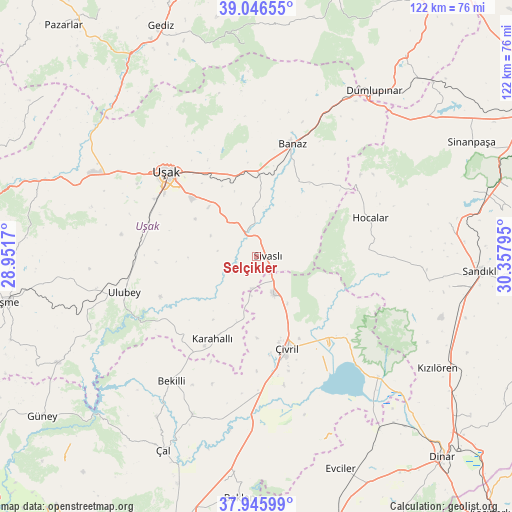
Selçikler GPS coordinates[2]
38° 29' 54.132" North, 29° 39' 17.352" East
| Map corner | latitude | longitude |
|---|---|---|
| Upper-left | 39.04655°, | 28.9517° |
| Center: | 38.49837°, | 29.65482° |
| Lower-right: | 37.94599°, | 30.35795° |
| Map W x H: | 122.4×122.4 km | = 76.1×76.1mi |
| max Lat: | 42.02683° ⇑52.8% North |
| Selçikler: | 38.49837° |
| min Lat: | ⇓47.2% South 35.9025° |
| min Long | Selçikler | max Long |
| 25.90902° | 29.65482° | 44.60099° |
| W 21.8%⇐ | ⇒78.2% E |
Elevation
Elevation of Selçikler is 905 m = 2969 ft, and this is 187.6 m = 615 ft above average elevation for this country.
| Max E: |
2682 m = 8799 ft | 38.5% |
| Selçikler | 905 m 2969 ft | |
| Avg. | 717.4 m = 2354 ft | |
Min E: |
0 m = 0 ft | 61.5% |
See also: Turkey elevation on elevation.city.
Geographical zone
Selçikler is located in North temperate zone (between Tropic of Cancer and the Arctic Circle). Distance of this Northern Tropic circle is 1674.7 km =1040.6 mi to South.| Distance of | km | miles | from Selçikler |
|---|---|---|---|
| North Pole | 5726.4 | 3558.2 | to North |
| Arctic Circle | 3120.6 | 1939.1 | to North |
| Tropic Cancer | 1674.7 | 1040.6 | to South |
| Equator | 4280.6 | 2659.8 | to South |


Nearby cities:
15 places around Selçikler: (largest is in red/bold)
• Akkent
45.4 km =28.2 mi,  212°
212°
• Banaz
27.8 km =17.3 mi,  17°
17°
• Bekilli
36.1 km =22.4 mi, 214°
• Bölme
28 km =17.4 mi,  299°
299°
• Güre
45.7 km =28.4 mi,  291°
291°
• Hocalar
28.6 km =17.8 mi,  71°
71°
• Homa
40.8 km =25.4 mi,  134°
134°
• Karahallı
22.5 km =14 mi, 208°
• Kızılcasöğüt
17 km =10.6 mi,  3°
3°
• Sivaslı
2.5 km =1.6 mi,  87°
87°
• Ulubey
32.8 km =20.4 mi,  254°
254°
• Uşak
29.1 km =18.1 mi,  311°
311°
• Çivril
23.1 km =14.4 mi,  161°
161°
• İlyaslı
41.2 km =25.6 mi, 286°
• İshaklı
45.6 km =28.3 mi,  136°
136°
Sources, notices
• [Note1] Compared only with cities in Turkey existing in our database
• [Src1] Map data: © OpenStreetMap contributors (CC-BY-SA)
• [Src2] Other city data from geonames.org with taken over terms of usage.
• [Src3] Geographical zone / Annual Mean Temperature by Robert A. Rohde @ Wikipedia
