Çivril geodata
Çivril (Denizli) is a seat of a second-order administrative division; located in Turkey in Europe/Istanbul (GMT+3) time zone. With population of 14,002 people, there are 407 cities with bigger population in this country. Compared to other cities in Turkey, 56.2% of cities are located further ↑North; 77.6% of cities are located further →East and 57.2% of cities have lower elevation than Çivril. Note1


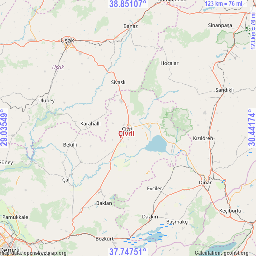
Çivril GPS coordinates[2]
38° 18' 5.004" North, 29° 44' 18.996" East
| Map corner | latitude | longitude |
|---|---|---|
| Upper-left | 38.85107°, | 29.03549° |
| Center: | 38.30139°, | 29.73861° |
| Lower-right: | 37.74751°, | 30.44174° |
| Map W x H: | 122.7×122.7 km | = 76.2×76.2mi |
| max Lat: | 42.02683° ⇑56.2% North |
| Çivril: | 38.30139° |
| min Lat: | ⇓43.8% South 35.9025° |
| min Long | Çivril | max Long |
| 25.90902° | 29.73861° | 44.60099° |
| W 22.4%⇐ | ⇒77.6% E |
Elevation
Elevation of Çivril is 828 m = 2717 ft, and this is 110.6 m = 363 ft above average elevation for this country.
| Max E: |
2682 m = 8799 ft | 42.8% |
| Çivril | 828 m 2717 ft | |
| Avg. | 717.4 m = 2354 ft | |
Min E: |
0 m = 0 ft | 57.2% |
See also: Turkey elevation on elevation.city.
Geographical zone
Çivril is located in North temperate zone (between Tropic of Cancer and the Arctic Circle). Distance of this Northern Tropic circle is 1652.8 km =1027 mi to South.| Distance of | km | miles | from Çivril |
|---|---|---|---|
| North Pole | 5748.3 | 3571.8 | to North |
| Arctic Circle | 3142.5 | 1952.7 | to North |
| Tropic Cancer | 1652.8 | 1027 | to South |
| Equator | 4258.7 | 2646.2 | to South |


Nearby cities:
15 places around Çivril: (largest is in red/bold)
• Akkent
35.5 km =22.1 mi,  242°
242°
• Baklan
37.8 km =23.5 mi,  197°
197°
• Bekilli
28.9 km =18 mi,  254°
254°
• Dazkırı
43.9 km =27.3 mi,  165°
165°
• Evciler
31.7 km =19.7 mi,  155°
155°
• Hocalar
36.7 km =22.8 mi,  32°
32°
• Homa
22.7 km =14.1 mi,  107°
107°
• Karahallı
18.3 km =11.4 mi,  276°
276°
• Kızılcasöğüt
39.4 km =24.5 mi,  350°
350°
• Kızılören
36.4 km =22.6 mi,  97°
97°
• Selçikler
23.1 km =14.4 mi,  341°
341°
• Sivaslı
22.5 km =14 mi, 347°
• Ulubey
41.2 km =25.6 mi,  288°
288°
• Çal
38.3 km =23.8 mi,  230°
230°
• İshaklı
26.5 km =16.5 mi,  115°
115°
Sources, notices
• [Note1] Compared only with cities in Turkey existing in our database
• [Src1] Map data: © OpenStreetMap contributors (CC-BY-SA)
• [Src2] Other city data from geonames.org with taken over terms of usage.
• [Src3] Geographical zone / Annual Mean Temperature by Robert A. Rohde @ Wikipedia
