Hocalar geodata
Hocalar (Afyonkarahisar) is a seat of a second-order administrative division; located in Turkey in Europe/Istanbul (GMT+3) time zone. With population of 2,588 people, there are 894 cities with bigger population in this country. Compared to other cities in Turkey, 51.8% of cities are located further ↑North; 76% of cities are located further →East and 73.1% of cities have lower elevation than Hocalar. Note1


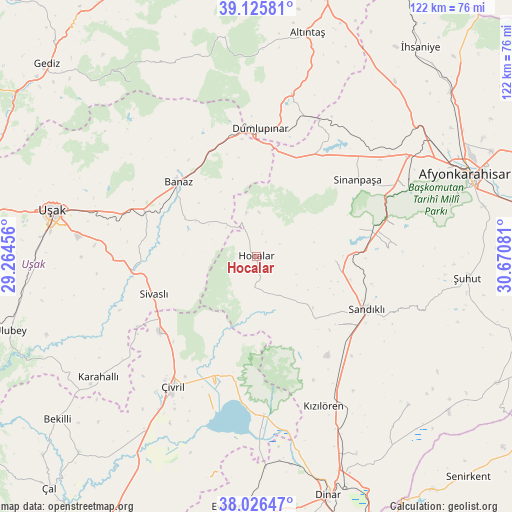
Hocalar GPS coordinates[2]
38° 34' 41.664" North, 29° 58' 3.648" East
| Map corner | latitude | longitude |
|---|---|---|
| Upper-left | 39.12581°, | 29.26456° |
| Center: | 38.57824°, | 29.96768° |
| Lower-right: | 38.02647°, | 30.67081° |
| Map W x H: | 122.2×122.2 km | = 75.9×75.9mi |
| max Lat: | 42.02683° ⇑51.8% North |
| Hocalar: | 38.57824° |
| min Lat: | ⇓48.2% South 35.9025° |
| min Long | Hocalar | max Long |
| 25.90902° | 29.96768° | 44.60099° |
| W 24%⇐ | ⇒76% E |
Elevation
Elevation of Hocalar is 1075 m = 3527 ft, and this is 357.6 m = 1173 ft above average elevation for this country.
| Max E: |
2682 m = 8799 ft | 26.9% |
| Hocalar | 1075 m 3527 ft | |
| Avg. | 717.4 m = 2354 ft | |
Min E: |
0 m = 0 ft | 73.1% |
See also: Turkey elevation on elevation.city.
Geographical zone
Hocalar is located in North temperate zone (between Tropic of Cancer and the Arctic Circle). Distance of this Northern Tropic circle is 1683.6 km =1046.1 mi to South.| Distance of | km | miles | from Hocalar |
|---|---|---|---|
| North Pole | 5717.6 | 3552.8 | to North |
| Arctic Circle | 3111.7 | 1933.5 | to North |
| Tropic Cancer | 1683.6 | 1046.1 | to South |
| Equator | 4289.5 | 2665.4 | to South |


Nearby cities:
15 places around Hocalar: (largest is in red/bold)
• Banaz
25.7 km =16 mi,  313°
313°
• Dumlupınar
30.7 km =19.1 mi,  1°
1°
• Homa
37.7 km =23.4 mi,  177°
177°
• Karadirek
18.9 km =11.7 mi,  93°
93°
• Karahallı
47.6 km =29.6 mi,  233°
233°
• Kızılcasöğüt
27.4 km =17 mi,  287°
287°
• Kızılören
39 km =24.2 mi,  155°
155°
• Sandıklı
29.1 km =18.1 mi,  115°
115°
• Selçikler
28.6 km =17.8 mi,  251°
251°
• Sinanpaşa
30.2 km =18.8 mi,  52°
52°
• Sivaslı
26.2 km =16.3 mi, 250°
• Uşak
49.9 km =31 mi,  282°
282°
• Çivril
36.7 km =22.8 mi,  212°
212°
• İshaklı
42.3 km =26.3 mi,  174°
174°
• Şuhut
50.5 km =31.4 mi,  95°
95°
Sources, notices
• [Note1] Compared only with cities in Turkey existing in our database
• [Src1] Map data: © OpenStreetMap contributors (CC-BY-SA)
• [Src2] Other city data from geonames.org with taken over terms of usage.
• [Src3] Geographical zone / Annual Mean Temperature by Robert A. Rohde @ Wikipedia
