Homa geodata
Homa (Denizli) is a seat of a third-order administrative division; located in Turkey in Europe/Istanbul (GMT+3) time zone. In our database, there are 1323 cities with bigger population. Compared to other cities in Turkey, 57.4% of cities are located further ↑North; 75.8% of cities are located further →East and 62.3% of cities have lower elevation than Homa. Note1


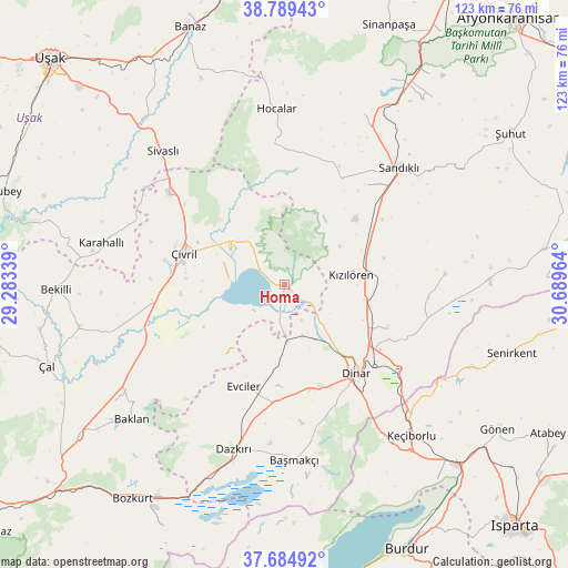
Homa GPS coordinates[2]
38° 14' 21.372" North, 29° 59' 11.436" East
| Map corner | latitude | longitude |
|---|---|---|
| Upper-left | 38.78943°, | 29.28339° |
| Center: | 38.23927°, | 29.98651° |
| Lower-right: | 37.68492°, | 30.68964° |
| Map W x H: | 122.8×122.8 km | = 76.3×76.3mi |
| max Lat: | 42.02683° ⇑57.4% North |
| Homa: | 38.23927° |
| min Lat: | ⇓42.6% South 35.9025° |
| min Long | Homa | max Long |
| 25.90902° | 29.98651° | 44.60099° |
| W 24.2%⇐ | ⇒75.8% E |
Elevation
Elevation of Homa is 916 m = 3005 ft, and this is 198.6 m = 652 ft above average elevation for this country.
| Max E: |
2682 m = 8799 ft | 37.7% |
| Homa | 916 m 3005 ft | |
| Avg. | 717.4 m = 2354 ft | |
Min E: |
0 m = 0 ft | 62.3% |
See also: Turkey elevation on elevation.city.
Geographical zone
Homa is located in North temperate zone (between Tropic of Cancer and the Arctic Circle). Distance of this Northern Tropic circle is 1645.9 km =1022.7 mi to South.| Distance of | km | miles | from Homa |
|---|---|---|---|
| North Pole | 5755.3 | 3576.2 | to North |
| Arctic Circle | 3149.4 | 1956.9 | to North |
| Tropic Cancer | 1645.9 | 1022.7 | to South |
| Equator | 4251.8 | 2641.9 | to South |


Nearby cities:
15 places around Homa: (largest is in red/bold)
• Başmakçı
38.1 km =23.7 mi,  176°
176°
• Dazkırı
37.3 km =23.2 mi,  197°
197°
• Dinar
24.9 km =15.5 mi,  141°
141°
• Dombay
21.6 km =13.4 mi,  115°
115°
• Evciler
23.7 km =14.7 mi, 201°
• Haydarlı
34.9 km =21.7 mi,  86°
86°
• Hocalar
37.7 km =23.4 mi,  357°
357°
• Karadirek
40.4 km =25.1 mi,  25°
25°
• Karahallı
40.8 km =25.4 mi,  282°
282°
• Kızılören
14.6 km =9.1 mi,  81°
81°
• Sandıklı
35.2 km =21.9 mi,  44°
44°
• Selçikler
40.8 km =25.4 mi,  314°
314°
• Sivaslı
39.2 km =24.4 mi,  317°
317°
• Çivril
22.7 km =14.1 mi,  287°
287°
• İshaklı
5 km =3.1 mi,  151°
151°
Sources, notices
• [Note1] Compared only with cities in Turkey existing in our database
• [Src1] Map data: © OpenStreetMap contributors (CC-BY-SA)
• [Src2] Other city data from geonames.org with taken over terms of usage.
• [Src3] Geographical zone / Annual Mean Temperature by Robert A. Rohde @ Wikipedia
