Kızılcasöğüt geodata
Kızılcasöğüt (Uşak) is a populated place; located in Turkey in Europe/Istanbul (GMT+3) time zone. With population of 2,024 people, there are 950 cities with bigger population in this country. Compared to other cities in Turkey, 50.8% of cities are located further ↑North; 78% of cities are located further →East and 62.1% of cities have lower elevation than Kızılcasöğüt. Note1


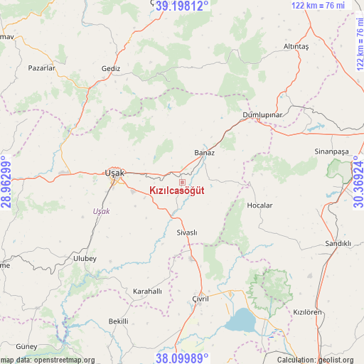
Kızılcasöğüt GPS coordinates[2]
38° 39' 3.996" North, 29° 39' 57.996" East
| Map corner | latitude | longitude |
|---|---|---|
| Upper-left | 39.19812°, | 28.96299° |
| Center: | 38.65111°, | 29.66611° |
| Lower-right: | 38.09989°, | 30.36924° |
| Map W x H: | 122.1×122.1 km | = 75.9×75.9mi |
| max Lat: | 42.02683° ⇑50.8% North |
| Kızılcasöğüt: | 38.65111° |
| min Lat: | ⇓49.2% South 35.9025° |
| min Long | Kızılcasöğ� | max Long |
| 25.90902° | 29.66611° | 44.60099° |
| W 22%⇐ | ⇒78% E |
Elevation
Elevation of Kızılcasöğüt is 914 m = 2999 ft, and this is 196.6 m = 645 ft above average elevation for this country.
| Max E: |
2682 m = 8799 ft | 37.9% |
| Kızılcasöğüt | 914 m 2999 ft | |
| Avg. | 717.4 m = 2354 ft | |
Min E: |
0 m = 0 ft | 62.1% |
See also: Turkey elevation on elevation.city.
Geographical zone
Kızılcasöğüt is located in North temperate zone (between Tropic of Cancer and the Arctic Circle). Distance of this Northern Tropic circle is 1691.7 km =1051.2 mi to South.| Distance of | km | miles | from Kızılcasöğüt |
|---|---|---|---|
| North Pole | 5709.5 | 3547.7 | to North |
| Arctic Circle | 3103.6 | 1928.5 | to North |
| Tropic Cancer | 1691.7 | 1051.2 | to South |
| Equator | 4297.6 | 2670.4 | to South |


Nearby cities:
15 places around Kızılcasöğüt: (largest is in red/bold)
• Banaz
12.1 km =7.5 mi,  37°
37°
• Bölme
25.6 km =15.9 mi,  262°
262°
• Dumlupınar
35.2 km =21.9 mi,  50°
50°
• Gediz
44.9 km =27.9 mi,  328°
328°
• Güre
43.3 km =26.9 mi,  270°
270°
• Hocalar
27.4 km =17 mi,  107°
107°
• Karadirek
45.9 km =28.5 mi,  101°
101°
• Karahallı
38.6 km =24 mi,  197°
197°
• Selçikler
17 km =10.6 mi,  183°
183°
• Sinanpaşa
51.1 km =31.8 mi,  78°
78°
• Sivaslı
16.9 km =10.5 mi,  174°
174°
• Ulubey
41.5 km =25.8 mi,  231°
231°
• Uşak
22.7 km =14.1 mi,  276°
276°
• Çivril
39.4 km =24.5 mi, 170°
• İlyaslı
40.8 km =25.4 mi, 262°
Sources, notices
• [Note1] Compared only with cities in Turkey existing in our database
• [Src1] Map data: © OpenStreetMap contributors (CC-BY-SA)
• [Src2] Other city data from geonames.org with taken over terms of usage.
• [Src3] Geographical zone / Annual Mean Temperature by Robert A. Rohde @ Wikipedia
