İshaklı geodata
İshaklı (Denizli) is a seat of a third-order administrative division; located in Turkey in Europe/Istanbul (GMT+3) time zone. In our database, there are 1323 cities with bigger population. Compared to other cities in Turkey, 58% of cities are located further ↑North; 75.6% of cities are located further →East and 56.7% of cities have lower elevation than İshaklı. Note1


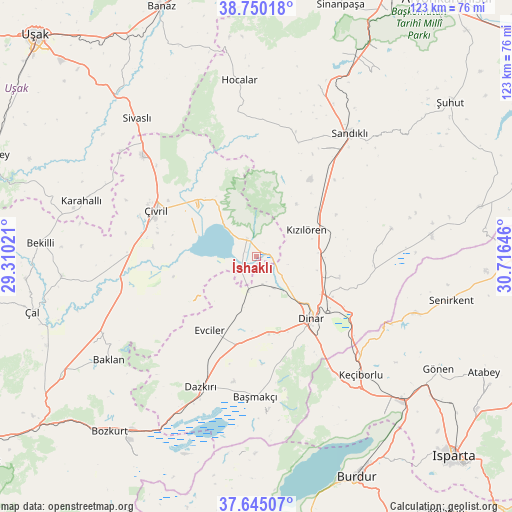
İshaklı GPS coordinates[2]
38° 11' 58.992" North, 30° 0' 47.988" East
| Map corner | latitude | longitude |
|---|---|---|
| Upper-left | 38.75018°, | 29.31021° |
| Center: | 38.19972°, | 30.01333° |
| Lower-right: | 37.64507°, | 30.71646° |
| Map W x H: | 122.9×122.9 km | = 76.4×76.4mi |
| max Lat: | 42.02683° ⇑58% North |
| İshaklı: | 38.19972° |
| min Lat: | ⇓42% South 35.9025° |
| min Long | İshaklı | max Long |
| 25.90902° | 30.01333° | 44.60099° |
| W 24.4%⇐ | ⇒75.6% E |
Elevation
Elevation of İshaklı is 823 m = 2700 ft, and this is 105.6 m = 346 ft above average elevation for this country.
| Max E: |
2682 m = 8799 ft | 43.3% |
| İshaklı | 823 m 2700 ft | |
| Avg. | 717.4 m = 2354 ft | |
Min E: |
0 m = 0 ft | 56.7% |
See also: Turkey elevation on elevation.city.
Geographical zone
İshaklı is located in North temperate zone (between Tropic of Cancer and the Arctic Circle). Distance of this Northern Tropic circle is 1641.5 km =1020 mi to South.| Distance of | km | miles | from İshaklı |
|---|---|---|---|
| North Pole | 5759.7 | 3578.9 | to North |
| Arctic Circle | 3153.8 | 1959.7 | to North |
| Tropic Cancer | 1641.5 | 1020 | to South |
| Equator | 4247.4 | 2639.2 | to South |


Nearby cities:
15 places around İshaklı: (largest is in red/bold)
• Baklan
43.2 km =26.8 mi,  235°
235°
• Başmakçı
33.6 km =20.9 mi,  180°
180°
• Dazkırı
34 km =21.1 mi,  203°
203°
• Dinar
20 km =12.4 mi,  138°
138°
• Dombay
17.8 km =11.1 mi,  106°
106°
• Evciler
20.8 km =12.9 mi,  212°
212°
• Haydarlı
33.2 km =20.6 mi,  78°
78°
• Hocalar
42.3 km =26.3 mi,  354°
354°
• Homa
5 km =3.1 mi,  331°
331°
• Karadirek
43.6 km =27.1 mi,  19°
19°
• Keçiborlu
38.2 km =23.7 mi, 138°
• Kızılören
13.7 km =8.5 mi,  61°
61°
• Sandıklı
37 km =23 mi,  37°
37°
• Uluborlu
40.5 km =25.2 mi, 109°
• Çivril
26.5 km =16.5 mi,  295°
295°
Sources, notices
• [Note1] Compared only with cities in Turkey existing in our database
• [Src1] Map data: © OpenStreetMap contributors (CC-BY-SA)
• [Src2] Other city data from geonames.org with taken over terms of usage.
• [Src3] Geographical zone / Annual Mean Temperature by Robert A. Rohde @ Wikipedia
