Akdağmadeni geodata
Akdağmadeni (Yozgat) is a seat of a second-order administrative division; located in Turkey in Europe/Istanbul (GMT+3) time zone. With population of 23,048 people, there are 304 cities with bigger population in this country. Compared to other cities in Turkey, 63.8% of cities are located further ↓South; 50.4% of cities are located further →East and 85.1% of cities have lower elevation than Akdağmadeni. Note1


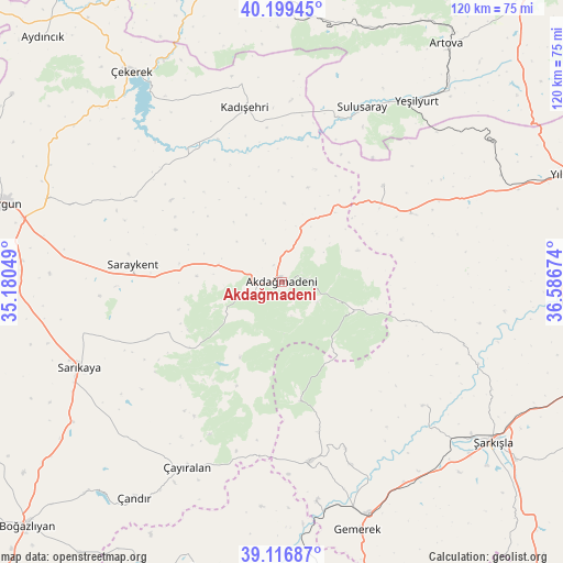
Akdağmadeni GPS coordinates[2]
39° 39' 37.008" North, 35° 53' 0.996" East
| Map corner | latitude | longitude |
|---|---|---|
| Upper-left | 40.19945°, | 35.18049° |
| Center: | 39.66028°, | 35.88361° |
| Lower-right: | 39.11687°, | 36.58674° |
| Map W x H: | 120.4×120.4 km | = 74.8×74.8mi |
| max Lat: | 42.02683° ⇑36.2% North |
| Akdağmadeni: | 39.66028° |
| min Lat: | ⇓63.8% South 35.9025° |
| min Long | Akdağmadeni | max Long |
| 25.90902° | 35.88361° | 44.60099° |
| W 49.6%⇐ | ⇒50.4% E |
Elevation
Elevation of Akdağmadeni is 1313 m = 4308 ft, and this is 595.6 m = 1954 ft above average elevation for this country.
| Max E: |
2682 m = 8799 ft | 14.9% |
| Akdağmadeni | 1313 m 4308 ft | |
| Avg. | 717.4 m = 2354 ft | |
Min E: |
0 m = 0 ft | 85.1% |
See also: Turkey elevation on elevation.city.
Geographical zone
Akdağmadeni is located in North temperate zone (between Tropic of Cancer and the Arctic Circle). Distance of this Northern Tropic circle is 1803.9 km =1120.9 mi to South.| Distance of | km | miles | from Akdağmadeni |
|---|---|---|---|
| North Pole | 5597.3 | 3478 | to North |
| Arctic Circle | 2991.4 | 1858.8 | to North |
| Tropic Cancer | 1803.9 | 1120.9 | to South |
| Equator | 4409.8 | 2740.1 | to South |


Nearby cities:
15 places around Akdağmadeni: (largest is in red/bold)
• Akcakışla
41.1 km =25.5 mi,  109°
109°
• Boztepe
58.7 km =36.5 mi,  0°
0°
• Gemerek
55.4 km =34.4 mi,  163°
163°
• Hasbek
31.3 km =19.4 mi,  246°
246°
• Kadışehri
38.1 km =23.7 mi,  348°
348°
• Ortaköy
40.1 km =24.9 mi,  131°
131°
• Saraykent
32.1 km =19.9 mi,  276°
276°
• Sarıkaya
47.2 km =29.3 mi, 246°
• Sulusaray
40.9 km =25.4 mi,  24°
24°
• Yavu
31.2 km =19.4 mi,  62°
62°
• Yeşilyurt
48.1 km =29.9 mi,  36°
36°
• Çandır
56.1 km =34.9 mi,  214°
214°
• Çayıralan
44.8 km =27.8 mi, 207°
• Çekerek
56.6 km =35.2 mi,  324°
324°
• Şarkışla
56.7 km =35.2 mi, 127°
Sources, notices
• [Note1] Compared only with cities in Turkey existing in our database
• [Src1] Map data: © OpenStreetMap contributors (CC-BY-SA)
• [Src2] Other city data from geonames.org with taken over terms of usage.
• [Src3] Geographical zone / Annual Mean Temperature by Robert A. Rohde @ Wikipedia
