Eymir geodata
Eymir (Yozgat) is a seat of a third-order administrative division; located in Turkey in Europe/Istanbul (GMT+3) time zone. In our database, there are 1323 cities with bigger population. Compared to other cities in Turkey, 69.3% of cities are located further ↓South; 53.4% of cities are located further →East and 82.1% of cities have lower elevation than Eymir. Note1


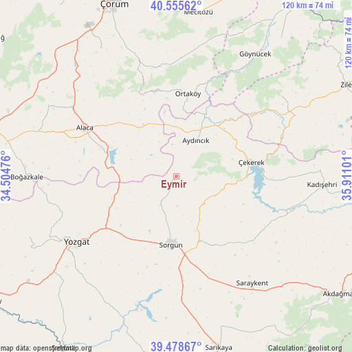
Eymir GPS coordinates[2]
40° 1' 9.372" North, 35° 12' 28.368" East
| Map corner | latitude | longitude |
|---|---|---|
| Upper-left | 40.55562°, | 34.50476° |
| Center: | 40.01927°, | 35.20788° |
| Lower-right: | 39.47867°, | 35.91101° |
| Map W x H: | 119.7×119.7 km | = 74.4×74.4mi |
| max Lat: | 42.02683° ⇑30.7% North |
| Eymir: | 40.01927° |
| min Lat: | ⇓69.3% South 35.9025° |
| min Long | Eymir | max Long |
| 25.90902° | 35.20788° | 44.60099° |
| W 46.6%⇐ | ⇒53.4% E |
Elevation
Elevation of Eymir is 1238 m = 4062 ft, and this is 520.6 m = 1708 ft above average elevation for this country.
| Max E: |
2682 m = 8799 ft | 17.9% |
| Eymir | 1238 m 4062 ft | |
| Avg. | 717.4 m = 2354 ft | |
Min E: |
0 m = 0 ft | 82.1% |
See also: Turkey elevation on elevation.city.
Geographical zone
Eymir is located in North temperate zone (between Tropic of Cancer and the Arctic Circle). Distance of this Northern Tropic circle is 1843.8 km =1145.7 mi to South.| Distance of | km | miles | from Eymir |
|---|---|---|---|
| North Pole | 5557.3 | 3453.1 | to North |
| Arctic Circle | 2951.4 | 1833.9 | to North |
| Tropic Cancer | 1843.8 | 1145.7 | to South |
| Equator | 4449.7 | 2764.9 | to South |


Nearby cities:
15 places around Eymir: (largest is in red/bold)
• Alaca
35.2 km =21.9 mi,  298°
298°
• Aydıncık
13.8 km =8.6 mi,  29°
29°
• Boğazkale
51 km =31.7 mi,  270°
270°
• Cemilbey
38.6 km =24 mi,  339°
339°
• Göynücek
50.1 km =31.1 mi, 32°
• Kadışehri
49.8 km =30.9 mi,  93°
93°
• Mecitözü
56.2 km =34.9 mi,  7°
7°
• Musabeyli
54 km =33.6 mi,  247°
247°
• Ortaköy
28.5 km =17.7 mi, 7°
• Osmanpaşa
48.5 km =30.1 mi,  205°
205°
• Saraykent
44.5 km =27.7 mi,  144°
144°
• Sorgun
23.3 km =14.5 mi,  184°
184°
• Yozgat
40.9 km =25.4 mi,  237°
237°
• Çekerek
25.1 km =15.6 mi,  76°
76°
• İğdir
44.9 km =27.9 mi,  52°
52°
Sources, notices
• [Note1] Compared only with cities in Turkey existing in our database
• [Src1] Map data: © OpenStreetMap contributors (CC-BY-SA)
• [Src2] Other city data from geonames.org with taken over terms of usage.
• [Src3] Geographical zone / Annual Mean Temperature by Robert A. Rohde @ Wikipedia
