Patnos geodata
Patnos (Ağrı) is a seat of a second-order administrative division; located in Turkey in Europe/Istanbul (GMT+3) time zone. With population of 87,451 people, there are 104 cities with bigger population in this country. Compared to other cities in Turkey, 57.7% of cities are located further ↓South; 96% of cities are located further ←West and 93.9% of cities have lower elevation than Patnos. Note1


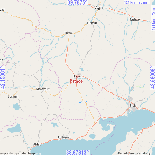
Patnos GPS coordinates[2]
39° 13' 29.748" North, 42° 51' 24.948" East
| Map corner | latitude | longitude |
|---|---|---|
| Upper-left | 39.7675°, | 42.15381° |
| Center: | 39.22493°, | 42.85693° |
| Lower-right: | 38.67813°, | 43.56006° |
| Map W x H: | 121.1×121.1 km | = 75.2×75.2mi |
| max Lat: | 42.02683° ⇑42.3% North |
| Patnos: | 39.22493° |
| min Lat: | ⇓57.7% South 35.9025° |
| min Long | Patnos | max Long |
| 25.90902° | 42.85693° | 44.60099° |
| W 96%⇐ | ⇒4% E |
Elevation
Elevation of Patnos is 1630 m = 5348 ft, and this is 912.6 m = 2994 ft above average elevation for this country.
| Max E: |
2682 m = 8799 ft | 6.1% |
| Patnos | 1630 m 5348 ft | |
| Avg. | 717.4 m = 2354 ft | |
Min E: |
0 m = 0 ft | 93.9% |
See also: Patnos elevation on elevation.city.
Geographical zone
Patnos is located in North temperate zone (between Tropic of Cancer and the Arctic Circle). Distance of this Northern Tropic circle is 1755.5 km =1090.8 mi to South.| Distance of | km | miles | from Patnos |
|---|---|---|---|
| North Pole | 5645.7 | 3508.1 | to North |
| Arctic Circle | 3039.8 | 1888.8 | to North |
| Tropic Cancer | 1755.5 | 1090.8 | to South |
| Equator | 4361.4 | 2710 | to South |


Nearby cities:
15 places around Patnos: (largest is in red/bold)
• Adilcevaz
48.6 km =30.2 mi,  192°
192°
• Aktuzla
50.6 km =31.4 mi,  283°
283°
• Bulanık
52.8 km =32.8 mi,  253°
253°
• Dedeli
18 km =11.2 mi,  108°
108°
• Deliçay
56.5 km =35.1 mi, 106°
• Doğansu
14.9 km =9.3 mi,  226°
226°
• Erciş
48.7 km =30.3 mi,  117°
117°
• Göldüzü
47.9 km =29.8 mi,  162°
162°
• Hamur
43.7 km =27.2 mi,  14°
14°
• Kocapınar
32.6 km =20.3 mi, 116°
• Malazgirt
29.1 km =18.1 mi, 252°
• Nurettin
30.7 km =19.1 mi, 281°
• Nurettin
37.8 km =23.5 mi,  270°
270°
• Sarısu
23.6 km =14.7 mi,  166°
166°
• Tutak
35.7 km =22.2 mi,  347°
347°
Sources, notices
• [Note1] Compared only with cities in Turkey existing in our database
• [Src1] Map data: © OpenStreetMap contributors (CC-BY-SA)
• [Src2] Other city data from geonames.org with taken over terms of usage.
• [Src3] Geographical zone / Annual Mean Temperature by Robert A. Rohde @ Wikipedia
