Erciş geodata
Erciş (Van) is a seat of a second-order administrative division; located in Turkey in Europe/Istanbul (GMT+3) time zone. With population of 91,915 people, there are 94 cities with bigger population in this country. Compared to other cities in Turkey, 54.9% of cities are located further ↓South; 98.1% of cities are located further ←West and 95% of cities have lower elevation than Erciş. Note1


Erciş GPS coordinates[2]
39° 1' 33.132" North, 43° 21' 34.704" East
| Map corner | latitude | longitude |
|---|---|---|
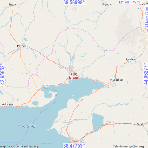
| Upper-left | 39.56999°, | 42.65652° |
| Center: | 39.02587°, | 43.35964° |
| Lower-right: | 38.47753°, | 44.06277° |
| Map W x H: | 121.5×121.5 km | = 75.5×75.5mi |
| max Lat: | 42.02683° ⇑45.1% North |
| Erciş: | 39.02587° |
| min Lat: | ⇓54.9% South 35.9025° |
| min Long | Erciş | max Long |
| 25.90902° | 43.35964° | 44.60099° |
| W 98.1%⇐ | ⇒1.9% E |
Elevation
Elevation of Erciş is 1682 m = 5518 ft, and this is 964.6 m = 3165 ft above average elevation for this country.
| Max E: |
2682 m = 8799 ft | 5% |
| Erciş | 1682 m 5518 ft | |
| Avg. | 717.4 m = 2354 ft | |
Min E: |
0 m = 0 ft | 95% |
See also: Erciş elevation on elevation.city.
Geographical zone
Erciş is located in North temperate zone (between Tropic of Cancer and the Arctic Circle). Distance of this Northern Tropic circle is 1733.4 km =1077.1 mi to South.| Distance of | km | miles | from Erciş |
|---|---|---|---|
| North Pole | 5667.8 | 3521.8 | to North |
| Arctic Circle | 3061.9 | 1902.6 | to North |
| Tropic Cancer | 1733.4 | 1077.1 | to South |
| Equator | 4339.3 | 2696.3 | to South |


Nearby cities:
15 places around Erciş: (largest is in red/bold)
• Adilcevaz
59.9 km =37.2 mi,  245°
245°
• Dedeli
31 km =19.3 mi,  302°
302°
• Deliçay
12.5 km =7.8 mi,  60°
60°
• Diyadin
63.2 km =39.3 mi,  25°
25°
• Dorutay
66.2 km =41.1 mi,  112°
112°
• Doğansu
55.4 km =34.4 mi,  282°
282°
• Erçek
48.4 km =30.1 mi,  149°
149°
• Göldüzü
37.8 km =23.5 mi,  231°
231°
• Kocapınar
16.1 km =10 mi, 298°
• Muradiye
34.3 km =21.3 mi,  97°
97°
• Patnos
48.7 km =30.3 mi, 297°
• Sarısu
37.9 km =23.5 mi,  268°
268°
• Timar
22.8 km =14.2 mi,  163°
163°
• Van
59.1 km =36.7 mi,  178°
178°
• Çaldıran
49.3 km =30.6 mi,  74°
74°
Sources, notices
• [Note1] Compared only with cities in Turkey existing in our database
• [Src1] Map data: © OpenStreetMap contributors (CC-BY-SA)
• [Src2] Other city data from geonames.org with taken over terms of usage.
• [Src3] Geographical zone / Annual Mean Temperature by Robert A. Rohde @ Wikipedia
