Hamur geodata
Hamur (Ağrı) is a seat of a second-order administrative division; located in Turkey in Europe/Istanbul (GMT+3) time zone. With population of 4,233 people, there are 764 cities with bigger population in this country. Compared to other cities in Turkey, 63.1% of cities are located further ↓South; 96.4% of cities are located further ←West and 95.3% of cities have lower elevation than Hamur. Note1


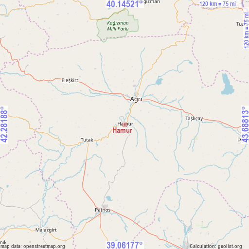
Hamur GPS coordinates[2]
39° 36' 20.196" North, 42° 59' 6" East
| Map corner | latitude | longitude |
|---|---|---|
| Upper-left | 40.14521°, | 42.28188° |
| Center: | 39.60561°, | 42.985° |
| Lower-right: | 39.06177°, | 43.68813° |
| Map W x H: | 120.5×120.5 km | = 74.9×74.9mi |
| max Lat: | 42.02683° ⇑36.9% North |
| Hamur: | 39.60561° |
| min Lat: | ⇓63.1% South 35.9025° |
| min Long | Hamur | max Long |
| 25.90902° | 42.985° | 44.60099° |
| W 96.4%⇐ | ⇒3.6% E |
Elevation
Elevation of Hamur is 1693 m = 5554 ft, and this is 975.6 m = 3201 ft above average elevation for this country.
| Max E: |
2682 m = 8799 ft | 4.7% |
| Hamur | 1693 m 5554 ft | |
| Avg. | 717.4 m = 2354 ft | |
Min E: |
0 m = 0 ft | 95.3% |
See also: Turkey elevation on elevation.city.
Geographical zone
Hamur is located in North temperate zone (between Tropic of Cancer and the Arctic Circle). Distance of this Northern Tropic circle is 1797.8 km =1117.1 mi to South.| Distance of | km | miles | from Hamur |
|---|---|---|---|
| North Pole | 5603.3 | 3481.7 | to North |
| Arctic Circle | 2997.4 | 1862.5 | to North |
| Tropic Cancer | 1797.8 | 1117.1 | to South |
| Equator | 4403.7 | 2736.3 | to South |


Nearby cities:
15 places around Hamur: (largest is in red/bold)
• Ağrı
13.9 km =8.6 mi,  24°
24°
• Cumaçay
38.5 km =23.9 mi,  26°
26°
• Dedeli
48.3 km =30 mi,  172°
172°
• Diyadin
59.3 km =36.8 mi,  97°
97°
• Doğansu
56.9 km =35.4 mi,  202°
202°
• Eleşkirt
34 km =21.1 mi,  308°
308°
• Elmalıdere
57.1 km =35.5 mi,  273°
273°
• Karakoyunlu
62.5 km =38.8 mi,  61°
61°
• Kocapınar
59.6 km =37 mi,  162°
162°
• Murat
23 km =14.3 mi,  71°
71°
• Nurettin
54.6 km =33.9 mi,  228°
228°
• Patnos
43.7 km =27.2 mi,  194°
194°
• Tahir
55.1 km =34.2 mi,  300°
300°
• Taşlıçay
33 km =20.5 mi,  85°
85°
• Tutak
20.2 km =12.6 mi,  248°
248°
Sources, notices
• [Note1] Compared only with cities in Turkey existing in our database
• [Src1] Map data: © OpenStreetMap contributors (CC-BY-SA)
• [Src2] Other city data from geonames.org with taken over terms of usage.
• [Src3] Geographical zone / Annual Mean Temperature by Robert A. Rohde @ Wikipedia
