Doğansu geodata
Doğansu (Ağrı) is a seat of a third-order administrative division; located in Turkey in Europe/Istanbul (GMT+3) time zone. In our database, there are 1323 cities with bigger population. Compared to other cities in Turkey, 56.4% of cities are located further ↓South; 95.3% of cities are located further ←West and 93.8% of cities have lower elevation than Doğansu. Note1


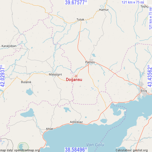
Doğansu GPS coordinates[2]
39° 7' 56.928" North, 42° 43' 56.964" East
| Map corner | latitude | longitude |
|---|---|---|
| Upper-left | 39.67577°, | 42.02937° |
| Center: | 39.13248°, | 42.73249° |
| Lower-right: | 38.58496°, | 43.43562° |
| Map W x H: | 121.3×121.3 km | = 75.4×75.4mi |
| max Lat: | 42.02683° ⇑43.6% North |
| Doğansu: | 39.13248° |
| min Lat: | ⇓56.4% South 35.9025° |
| min Long | Doğansu | max Long |
| 25.90902° | 42.73249° | 44.60099° |
| W 95.3%⇐ | ⇒4.7% E |
Elevation
Elevation of Doğansu is 1619 m = 5312 ft, and this is 901.6 m = 2958 ft above average elevation for this country.
| Max E: |
2682 m = 8799 ft | 6.2% |
| Doğansu | 1619 m 5312 ft | |
| Avg. | 717.4 m = 2354 ft | |
Min E: |
0 m = 0 ft | 93.8% |
See also: Turkey elevation on elevation.city.
Geographical zone
Doğansu is located in North temperate zone (between Tropic of Cancer and the Arctic Circle). Distance of this Northern Tropic circle is 1745.2 km =1084.4 mi to South.| Distance of | km | miles | from Doğansu |
|---|---|---|---|
| North Pole | 5655.9 | 3514.4 | to North |
| Arctic Circle | 3050.1 | 1895.2 | to North |
| Tropic Cancer | 1745.2 | 1084.4 | to South |
| Equator | 4351.1 | 2703.6 | to South |


Nearby cities:
15 places around Doğansu: (largest is in red/bold)
• Adilcevaz
37.1 km =23.1 mi,  180°
180°
• Ahlat
47.9 km =29.8 mi,  207°
207°
• Aktuzla
44.3 km =27.5 mi,  299°
299°
• Bulanık
40.1 km =24.9 mi,  262°
262°
• Dedeli
28.2 km =17.5 mi,  80°
80°
• Erciş
55.4 km =34.4 mi,  102°
102°
• Göldüzü
43.3 km =26.9 mi,  145°
145°
• Kocapınar
40.2 km =25 mi, 95°
• Malazgirt
17.1 km =10.6 mi,  275°
275°
• Nurettin
25.5 km =15.8 mi,  310°
310°
• Nurettin
29.1 km =18.1 mi,  291°
291°
• Ovakışla
50.2 km =31.2 mi,  225°
225°
• Patnos
14.9 km =9.3 mi,  46°
46°
• Sarısu
20.6 km =12.8 mi,  127°
127°
• Tutak
45.2 km =28.1 mi,  3°
3°
Sources, notices
• [Note1] Compared only with cities in Turkey existing in our database
• [Src1] Map data: © OpenStreetMap contributors (CC-BY-SA)
• [Src2] Other city data from geonames.org with taken over terms of usage.
• [Src3] Geographical zone / Annual Mean Temperature by Robert A. Rohde @ Wikipedia
