Sarısu geodata
Sarısu (Ağrı) is a seat of a third-order administrative division; located in Turkey in Europe/Istanbul (GMT+3) time zone. In our database, there are 1323 cities with bigger population. Compared to other cities in Turkey, 54.7% of cities are located further ↓South; 96.3% of cities are located further ←West and 96.9% of cities have lower elevation than Sarısu. Note1


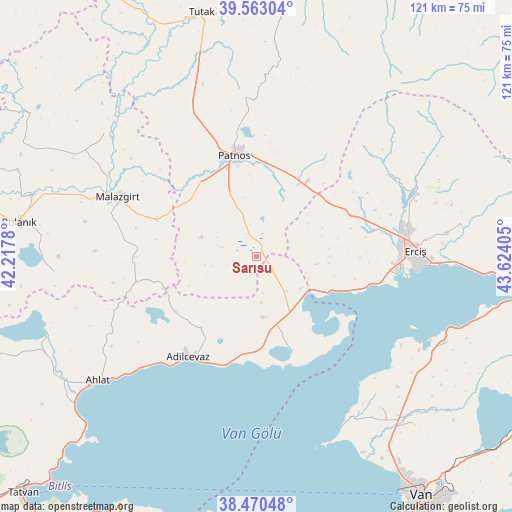
Sarısu GPS coordinates[2]
39° 1' 7.932" North, 42° 55' 15.312" East
| Map corner | latitude | longitude |
|---|---|---|
| Upper-left | 39.56304°, | 42.2178° |
| Center: | 39.01887°, | 42.92092° |
| Lower-right: | 38.47048°, | 43.62405° |
| Map W x H: | 121.5×121.5 km | = 75.5×75.5mi |
| max Lat: | 42.02683° ⇑45.3% North |
| Sarısu: | 39.01887° |
| min Lat: | ⇓54.7% South 35.9025° |
| min Long | Sarısu | max Long |
| 25.90902° | 42.92092° | 44.60099° |
| W 96.3%⇐ | ⇒3.7% E |
Elevation
Elevation of Sarısu is 1785 m = 5856 ft, and this is 1067.6 m = 3503 ft above average elevation for this country.
| Max E: |
2682 m = 8799 ft | 3.1% |
| Sarısu | 1785 m 5856 ft | |
| Avg. | 717.4 m = 2354 ft | |
Min E: |
0 m = 0 ft | 96.9% |
See also: Turkey elevation on elevation.city.
Geographical zone
Sarısu is located in North temperate zone (between Tropic of Cancer and the Arctic Circle). Distance of this Northern Tropic circle is 1732.6 km =1076.6 mi to South.| Distance of | km | miles | from Sarısu |
|---|---|---|---|
| North Pole | 5668.6 | 3522.3 | to North |
| Arctic Circle | 3062.7 | 1903.1 | to North |
| Tropic Cancer | 1732.6 | 1076.6 | to South |
| Equator | 4338.5 | 2695.8 | to South |


Nearby cities:
15 places around Sarısu: (largest is in red/bold)
• Adilcevaz
29.4 km =18.3 mi,  213°
213°
• Ahlat
48.5 km =30.1 mi,  231°
231°
• Bulanık
56.6 km =35.2 mi,  277°
277°
• Dedeli
20.8 km =12.9 mi,  33°
33°
• Deliçay
49.2 km =30.6 mi,  81°
81°
• Doğansu
20.6 km =12.8 mi,  307°
307°
• Erciş
37.9 km =23.5 mi,  88°
88°
• Göldüzü
24.4 km =15.2 mi,  159°
159°
• Kocapınar
25.2 km =15.7 mi,  70°
70°
• Malazgirt
36.2 km =22.5 mi,  293°
293°
• Nurettin
46.1 km =28.6 mi, 309°
• Nurettin
49.2 km =30.6 mi,  298°
298°
• Ovakışla
56.9 km =35.4 mi,  246°
246°
• Patnos
23.6 km =14.7 mi,  346°
346°
• Timar
49.1 km =30.5 mi,  115°
115°
Sources, notices
• [Note1] Compared only with cities in Turkey existing in our database
• [Src1] Map data: © OpenStreetMap contributors (CC-BY-SA)
• [Src2] Other city data from geonames.org with taken over terms of usage.
• [Src3] Geographical zone / Annual Mean Temperature by Robert A. Rohde @ Wikipedia
