Okçular geodata
Okçular (Siirt) is a populated place; located in Turkey in Europe/Istanbul (GMT+3) time zone. With population of 1,002 people, there are 1089 cities with bigger population in this country. Compared to other cities in Turkey, 69.6% of cities are located further ↑North; 93.8% of cities are located further ←West and 89.7% of cities have lower elevation than Okçular. Note1


Okçular GPS coordinates[2]
37° 44' 29.472" North, 42° 26' 26.7" East
| Map corner | latitude | longitude |
|---|---|---|
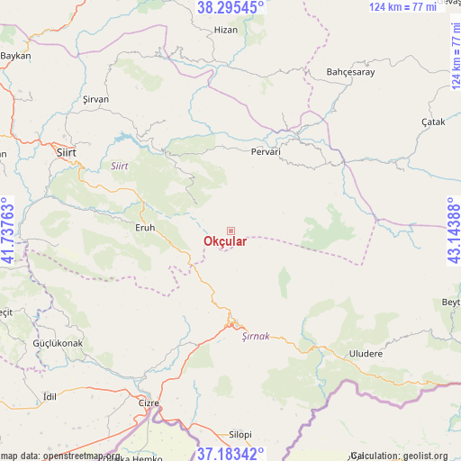
| Upper-left | 38.29545°, | 41.73763° |
| Center: | 37.74152°, | 42.44075° |
| Lower-right: | 37.18342°, | 43.14388° |
| Map W x H: | 123.6×123.6 km | = 76.8×76.8mi |
| max Lat: | 42.02683° ⇑69.6% North |
| Okçular: | 37.74152° |
| min Lat: | ⇓30.4% South 35.9025° |
| min Long | Okçular | max Long |
| 25.90902° | 42.44075° | 44.60099° |
| W 93.8%⇐ | ⇒6.2% E |
Elevation
Elevation of Okçular is 1471 m = 4826 ft, and this is 753.6 m = 2472 ft above average elevation for this country.
| Max E: |
2682 m = 8799 ft | 10.3% |
| Okçular | 1471 m 4826 ft | |
| Avg. | 717.4 m = 2354 ft | |
Min E: |
0 m = 0 ft | 89.7% |
See also: Turkey elevation on elevation.city.
Geographical zone
Okçular is located in North temperate zone (between Tropic of Cancer and the Arctic Circle). Distance of this Northern Tropic circle is 1590.5 km =988.3 mi to South.| Distance of | km | miles | from Okçular |
|---|---|---|---|
| North Pole | 5810.6 | 3610.5 | to North |
| Arctic Circle | 3204.7 | 1991.3 | to North |
| Tropic Cancer | 1590.5 | 988.3 | to South |
| Equator | 4196.5 | 2607.6 | to South |


Nearby cities:
15 places around Okçular: (largest is in red/bold)
• Ayvalıbağ
24.2 km =15 mi,  8°
8°
• Doğanca
11.6 km =7.2 mi,  303°
303°
• Eruh
23.4 km =14.5 mi,  270°
270°
• Gökbudak
25.7 km =16 mi,  45°
45°
• Gökçekoru
23.9 km =14.9 mi,  1°
1°
• Gölgelikonak
27.7 km =17.2 mi,  276°
276°
• Güleçler
25.1 km =15.6 mi,  20°
20°
• Karasungur
18.1 km =11.2 mi,  330°
330°
• Ormandalı
22.6 km =14 mi, 10°
• Palamutlu
27.1 km =16.8 mi,  309°
309°
• Pervari
23.6 km =14.7 mi, 23°
• Taşdibek
26.5 km =16.5 mi, 331°
• Yeniaydın
15.4 km =9.6 mi,  358°
358°
• Yukarı Balcılar
24.1 km =15 mi,  39°
39°
• Şırnak
25.3 km =15.7 mi,  177°
177°
Sources, notices
• [Note1] Compared only with cities in Turkey existing in our database
• [Src1] Map data: © OpenStreetMap contributors (CC-BY-SA)
• [Src2] Other city data from geonames.org with taken over terms of usage.
• [Src3] Geographical zone / Annual Mean Temperature by Robert A. Rohde @ Wikipedia
