Gökçekoru geodata
Gökçekoru (Siirt) is a populated place; located in Turkey in Europe/Istanbul (GMT+3) time zone. With population of 1,045 people, there are 1081 cities with bigger population in this country. Compared to other cities in Turkey, 62.6% of cities are located further ↑North; 93.9% of cities are located further ←West and 78.4% of cities have lower elevation than Gökçekoru. Note1


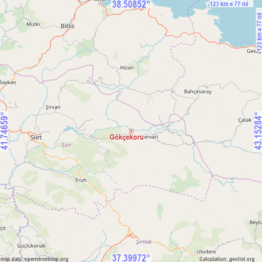
Gökçekoru GPS coordinates[2]
37° 57' 22.356" North, 42° 26' 58.956" East
| Map corner | latitude | longitude |
|---|---|---|
| Upper-left | 38.50852°, | 41.74659° |
| Center: | 37.95621°, | 42.44971° |
| Lower-right: | 37.39972°, | 43.15284° |
| Map W x H: | 123.3×123.3 km | = 76.6×76.6mi |
| max Lat: | 42.02683° ⇑62.6% North |
| Gökçekoru: | 37.95621° |
| min Lat: | ⇓37.4% South 35.9025° |
| min Long | Gökçekoru | max Long |
| 25.90902° | 42.44971° | 44.60099° |
| W 93.9%⇐ | ⇒6.1% E |
Elevation
Elevation of Gökçekoru is 1161 m = 3809 ft, and this is 443.6 m = 1455 ft above average elevation for this country.
| Max E: |
2682 m = 8799 ft | 21.6% |
| Gökçekoru | 1161 m 3809 ft | |
| Avg. | 717.4 m = 2354 ft | |
Min E: |
0 m = 0 ft | 78.4% |
See also: Turkey elevation on elevation.city.
Geographical zone
Gökçekoru is located in North temperate zone (between Tropic of Cancer and the Arctic Circle). Distance of this Northern Tropic circle is 1614.4 km =1003.1 mi to South.| Distance of | km | miles | from Gökçekoru |
|---|---|---|---|
| North Pole | 5786.7 | 3595.7 | to North |
| Arctic Circle | 3180.8 | 1976.5 | to North |
| Tropic Cancer | 1614.4 | 1003.1 | to South |
| Equator | 4220.3 | 2622.4 | to South |


Nearby cities:
15 places around Gökçekoru: (largest is in red/bold)
• Akşar
17.6 km =10.9 mi,  24°
24°
• Ayvalıbağ
2.6 km =1.6 mi,  87°
87°
• Beğendik
17.5 km =10.9 mi,  82°
82°
• Doğanca
20.3 km =12.6 mi,  210°
210°
• Gökbudak
18.4 km =11.4 mi,  108°
108°
• Güleçler
7.8 km =4.8 mi, 92°
• Karasungur
12.5 km =7.8 mi,  230°
230°
• Ormandalı
3.5 km =2.2 mi,  116°
116°
• Palamutlu
22.7 km =14.1 mi,  252°
252°
• Pervari
9 km =5.6 mi,  104°
104°
• Simos
16.3 km =10.1 mi,  46°
46°
• Taşdibek
13.6 km =8.5 mi,  267°
267°
• Yeniaydın
8.6 km =5.3 mi,  188°
188°
• Yukarı Balcılar
15.6 km =9.7 mi, 110°
• Özpınar
18.8 km =11.7 mi,  286°
286°
Sources, notices
• [Note1] Compared only with cities in Turkey existing in our database
• [Src1] Map data: © OpenStreetMap contributors (CC-BY-SA)
• [Src2] Other city data from geonames.org with taken over terms of usage.
• [Src3] Geographical zone / Annual Mean Temperature by Robert A. Rohde @ Wikipedia
