Palamutlu geodata
Palamutlu (Siirt) is a populated place; located in Turkey in Europe/Istanbul (GMT+3) time zone. With population of 1,368 people, there are 1024 cities with bigger population in this country. Compared to other cities in Turkey, 65.2% of cities are located further ↑North; 92.1% of cities are located further ←West and 88% of cities have lower elevation than Palamutlu. Note1


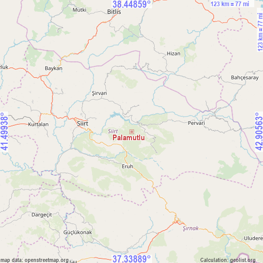
Palamutlu GPS coordinates[2]
37° 53' 44.988" North, 42° 12' 9" East
| Map corner | latitude | longitude |
|---|---|---|
| Upper-left | 38.44859°, | 41.49938° |
| Center: | 37.89583°, | 42.2025° |
| Lower-right: | 37.33889°, | 42.90563° |
| Map W x H: | 123.4×123.4 km | = 76.7×76.7mi |
| max Lat: | 42.02683° ⇑65.2% North |
| Palamutlu: | 37.89583° |
| min Lat: | ⇓34.8% South 35.9025° |
| min Long | Palamutlu | max Long |
| 25.90902° | 42.2025° | 44.60099° |
| W 92.1%⇐ | ⇒7.9% E |
Elevation
Elevation of Palamutlu is 1396 m = 4580 ft, and this is 678.6 m = 2226 ft above average elevation for this country.
| Max E: |
2682 m = 8799 ft | 12% |
| Palamutlu | 1396 m 4580 ft | |
| Avg. | 717.4 m = 2354 ft | |
Min E: |
0 m = 0 ft | 88% |
See also: Turkey elevation on elevation.city.
Geographical zone
Palamutlu is located in North temperate zone (between Tropic of Cancer and the Arctic Circle). Distance of this Northern Tropic circle is 1607.7 km =999 mi to South.| Distance of | km | miles | from Palamutlu |
|---|---|---|---|
| North Pole | 5793.4 | 3599.9 | to North |
| Arctic Circle | 3187.6 | 1980.7 | to North |
| Tropic Cancer | 1607.7 | 999 | to South |
| Equator | 4213.6 | 2618.2 | to South |


Nearby cities:
15 places around Palamutlu: (largest is in red/bold)
• Doğanca
15.6 km =9.7 mi,  133°
133°
• Durankaya
10.2 km =6.3 mi,  349°
349°
• Ekmekçiler
6.7 km =4.2 mi,  260°
260°
• Eruh
17.3 km =10.7 mi,  188°
188°
• Gökçekoru
22.7 km =14.1 mi,  72°
72°
• Gölgelikonak
15.5 km =9.6 mi,  205°
205°
• Karasungur
12.1 km =7.5 mi,  96°
96°
• Meydandere
9.9 km =6.2 mi,  289°
289°
• Siirt
23.2 km =14.4 mi,  279°
279°
• Taşdibek
10.1 km =6.3 mi,  53°
53°
• Taşlı
11.7 km =7.3 mi,  329°
329°
• Tillo
17.7 km =11 mi, 289°
• Yeniaydın
20.5 km =12.7 mi,  94°
94°
• Özpınar
12.6 km =7.8 mi,  16°
16°
• İkizbağlar
22.1 km =13.7 mi, 294°
Sources, notices
• [Note1] Compared only with cities in Turkey existing in our database
• [Src1] Map data: © OpenStreetMap contributors (CC-BY-SA)
• [Src2] Other city data from geonames.org with taken over terms of usage.
• [Src3] Geographical zone / Annual Mean Temperature by Robert A. Rohde @ Wikipedia
