Doğanca geodata
Doğanca (Siirt) is a seat of a third-order administrative division; located in Turkey in Europe/Istanbul (GMT+3) time zone. With population of 1,969 people, there are 962 cities with bigger population in this country. Compared to other cities in Turkey, 68.5% of cities are located further ↑North; 92.9% of cities are located further ←West and 87% of cities have lower elevation than Doğanca. Note1


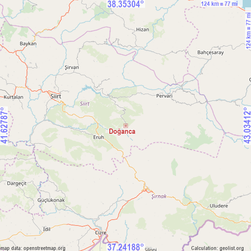
Doğanca GPS coordinates[2]
37° 47' 58.38" North, 42° 19' 51.564" East
| Map corner | latitude | longitude |
|---|---|---|
| Upper-left | 38.35304°, | 41.62787° |
| Center: | 37.79955°, | 42.33099° |
| Lower-right: | 37.24188°, | 43.03412° |
| Map W x H: | 123.5×123.5 km | = 76.7×76.7mi |
| max Lat: | 42.02683° ⇑68.5% North |
| Doğanca: | 37.79955° |
| min Lat: | ⇓31.5% South 35.9025° |
| min Long | Doğanca | max Long |
| 25.90902° | 42.33099° | 44.60099° |
| W 92.9%⇐ | ⇒7.1% E |
Elevation
Elevation of Doğanca is 1367 m = 4485 ft, and this is 649.6 m = 2131 ft above average elevation for this country.
| Max E: |
2682 m = 8799 ft | 13% |
| Doğanca | 1367 m 4485 ft | |
| Avg. | 717.4 m = 2354 ft | |
Min E: |
0 m = 0 ft | 87% |
See also: Turkey elevation on elevation.city.
Geographical zone
Doğanca is located in North temperate zone (between Tropic of Cancer and the Arctic Circle). Distance of this Northern Tropic circle is 1597 km =992.3 mi to South.| Distance of | km | miles | from Doğanca |
|---|---|---|---|
| North Pole | 5804.1 | 3606.5 | to North |
| Arctic Circle | 3198.3 | 1987.3 | to North |
| Tropic Cancer | 1597 | 992.3 | to South |
| Equator | 4202.9 | 2611.6 | to South |


Nearby cities:
15 places around Doğanca: (largest is in red/bold)
• Ayvalıbağ
21.8 km =13.5 mi,  36°
36°
• Dikboğaz
22.9 km =14.2 mi,  239°
239°
• Ekmekçiler
20.3 km =12.6 mi,  298°
298°
• Eruh
15.2 km =9.4 mi,  245°
245°
• Gökçekoru
20.3 km =12.6 mi,  30°
30°
• Gölgelikonak
18.2 km =11.3 mi,  259°
259°
• Karasungur
9.4 km =5.8 mi,  4°
4°
• Okçular
11.6 km =7.2 mi,  123°
123°
• Ormandalı
20.9 km =13 mi, 40°
• Palamutlu
15.6 km =9.7 mi,  313°
313°
• Pervari
24.4 km =15.2 mi,  51°
51°
• Serhatta
22.6 km =14 mi,  227°
227°
• Taşdibek
17.1 km =10.6 mi,  349°
349°
• Yeniaydın
12.8 km =8 mi, 45°
• Özpınar
24.1 km =15 mi,  341°
341°
Sources, notices
• [Note1] Compared only with cities in Turkey existing in our database
• [Src1] Map data: © OpenStreetMap contributors (CC-BY-SA)
• [Src2] Other city data from geonames.org with taken over terms of usage.
• [Src3] Geographical zone / Annual Mean Temperature by Robert A. Rohde @ Wikipedia
