Yeniaydın geodata
Yeniaydın (Siirt) is a populated place; located in Turkey in Europe/Istanbul (GMT+3) time zone. With population of 625 people, there are 1236 cities with bigger population in this country. Compared to other cities in Turkey, 66% of cities are located further ↑North; 93.7% of cities are located further ←West and 89.4% of cities have lower elevation than Yeniaydın. Note1


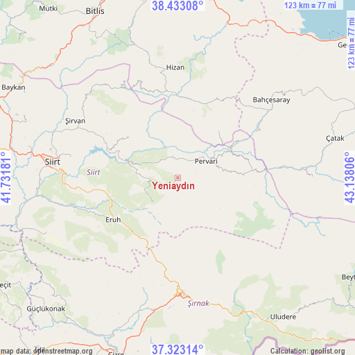
Yeniaydın GPS coordinates[2]
37° 52' 48.72" North, 42° 26' 5.748" East
| Map corner | latitude | longitude |
|---|---|---|
| Upper-left | 38.43308°, | 41.73181° |
| Center: | 37.8802°, | 42.43493° |
| Lower-right: | 37.32314°, | 43.13806° |
| Map W x H: | 123.4×123.4 km | = 76.7×76.7mi |
| max Lat: | 42.02683° ⇑66% North |
| Yeniaydın: | 37.8802° |
| min Lat: | ⇓34% South 35.9025° |
| min Long | Yeniaydın | max Long |
| 25.90902° | 42.43493° | 44.60099° |
| W 93.7%⇐ | ⇒6.3% E |
Elevation
Elevation of Yeniaydın is 1453 m = 4767 ft, and this is 735.6 m = 2413 ft above average elevation for this country.
| Max E: |
2682 m = 8799 ft | 10.6% |
| Yeniaydın | 1453 m 4767 ft | |
| Avg. | 717.4 m = 2354 ft | |
Min E: |
0 m = 0 ft | 89.4% |
See also: Turkey elevation on elevation.city.
Geographical zone
Yeniaydın is located in North temperate zone (between Tropic of Cancer and the Arctic Circle). Distance of this Northern Tropic circle is 1606 km =997.9 mi to South.| Distance of | km | miles | from Yeniaydın |
|---|---|---|---|
| North Pole | 5795.2 | 3601 | to North |
| Arctic Circle | 3189.3 | 1981.7 | to North |
| Tropic Cancer | 1606 | 997.9 | to South |
| Equator | 4211.9 | 2617.2 | to South |


Nearby cities:
15 places around Yeniaydın: (largest is in red/bold)
• Ayvalıbağ
9.4 km =5.8 mi,  24°
24°
• Beğendik
21.5 km =13.4 mi,  60°
60°
• Doğanca
12.8 km =8 mi,  225°
225°
• Gökbudak
18.9 km =11.7 mi,  82°
82°
• Gökçekoru
8.6 km =5.3 mi,  8°
8°
• Güleçler
12.2 km =7.6 mi,  48°
48°
• Karasungur
8.3 km =5.2 mi,  272°
272°
• Okçular
15.4 km =9.6 mi,  178°
178°
• Ormandalı
8.2 km =5.1 mi,  32°
32°
• Palamutlu
20.5 km =12.7 mi, 274°
• Pervari
11.8 km =7.3 mi, 58°
• Simos
23.6 km =14.7 mi, 33°
• Taşdibek
14.5 km =9 mi,  302°
302°
• Yukarı Balcılar
16.2 km =10.1 mi, 79°
• Özpınar
21.7 km =13.5 mi,  309°
309°
Sources, notices
• [Note1] Compared only with cities in Turkey existing in our database
• [Src1] Map data: © OpenStreetMap contributors (CC-BY-SA)
• [Src2] Other city data from geonames.org with taken over terms of usage.
• [Src3] Geographical zone / Annual Mean Temperature by Robert A. Rohde @ Wikipedia
